Sunday, 24 July 2011

8 Rope Lake Head to Kimmeridge

View over Kimmeridge

After another month's gap we continue our slow progress along the SW Coast Path. We decided to park on the cliff in Kimmeridge Bay, which would be the end point of the walk. This meant in effect repeating a walk from Kingston to Kimmeridge which we did in January - but in reverse and with a different starting point. We started therefore by walking inland up to an through Kimmeridge village, past the church and up the road. This offered increasingly fine view back over the village and the bay.
At this point we made a further climb up to the top of the steep ridge which overlooks Kimmeridge and more less follows the line of the coast to the east. The map shows this as Smedmore Hill and although the contour lines are hard to read, it is clearly about 200m above sea level - so a pretty decent climb from where we had started.

The views from the ridge were excellent, and as we neared Swyre Head there were also fine views inland to the north west. Here is Swyre Head, with the sea behind, seen from the ridge.


We had climbed Swyre Head (203m) on the previous leg of the Coast Path and on January's walk and we were rather looking forward to going down it for a change. It was indeed much easier, but still quite hard on the knees. However, the fine views to the west were a compensation.


Having by now walked four miles, we started on the Coast Path itself. This is an undramatic section, with the Kimmeridge Ledges (limestone) being the most notable feature.


As we approached Kimmeridge, the Clavell Tower folly, the other highlight, presented itself for our inspection (its story is described in January's post).


,

Just past the folly, you begin the descent to Kimmeridge Bay, with the westward continuation of the Smedmore Hill ridge in view behind it.


Conditions: sunny, hot.

Distance: about 6 miles, of which only 2 were on the Coast path. Distance covered now 21 miles.

Map: Explorer OL15 (Purbeck and South Dorset).

Rating: four stars.


Sightings

I think this lovely pink flower may be Red Soapwort, but I am not completely sure. I could not definitively locate it in my wild flower books.

Tuesday, 14 June 2011

7 Chapman's Pool to Rope Lake Head

Looking back towards St Aldhelm's Head

After a two months' gap, today offered an opportunity to resume our progress, by means of circular walks, along the South West Coast Path. We started at a car park to the west of Kingston, just by the entrance to Encombe Park, and walked back along the lane to the village. There were fine views to the left towards Corfe Castle. You could very clearly see the way in which the castle perches on a self-contained hill, with the Purbeck ridge rising on either side of it. What led to the interruption of the ridge?


In Kingston, we turned visited the church of St James and then turned right towards the sea. We were pleased to immediately identify it as Victorian. It turns out to be by the eminent architect G E Street  and was built in the 1870s, lavishly funded by the third Earl of Eldon. Pevsner describes it as his (Street's) "grandest church in the country".


We followed the road due south as it gradually became a track. After about a kilometre, we forked left on a permissive path aiming for the precise point at which we left the Coastal Path in April. We were pleased to find it successfully, but something went slightly awry because we had to carefully climb over a barbed wire fence at the end.

The path is a long way inland here, forced away from the coast by the steep ravine at the back of Chapman's Pool. As we walked along we could see the rocky side of Emmetts Hill, and remembered the many steps we had climbed up to reach it on the last leg from Winspit to Chapman's Pool.


Soon the path opened out into a wide glacial valley as we curved round under a fine rounded, but seemingly unnamed, hill 136m above sea level. When then took a path on the left, leading right down to the coast. This is the view back.


Now we climbed this leg's set of steps: about 200 of them leading up to the top of Houns Tout cliff, at 140m. The view back towards Chapman's Pool and St Aldhelm's head was exhilarating.


We were delighted to find a sun-warmed stone bench looking west and sat there for a while taking a breather and enjoying the view towards Rope Lake Head - the second headland in the picture, the first is Egmont Bight.


There now followed a long descent and then a relatively flat section, with Swyre Head, the highest point along the Dorset coast at 203m, rising to the right.


Just before Rope Lake Head, we took the path which leads, over a kilometer or so of steady climbing, to the top of Swyre Head. We came this way in January walking from Kimmeridge, to the west, so we knew exactly what to expect. Last time, it had been raining and the slippery mud added considerably to the difficulty. Today it was dry, but still a decent climb.

As we approached the top, with a hint of early sunset, the view to the west towards Kimmeridge Bay opened up.


The final stage back to the car park followed the line of the ridge overlooking the stretch of coast we had just walked along. The curve of the ridge mirrored the curve of the coastline. In the valley below Encombe House nestled, almost invisibly, in its private park.

Conditions: sunny, hot.

Distance: about 6 miles, of which about about 3 was on the Coast Path. Distance covered now 19 miles.

Map: Explorer OL15 (Purbeck and South Dorset)

Rating: four and a half stars


Sightings

Quite a good day for butterflies: Large and Small White, Meadow Brown, Small Heath, Small Tortoiseshell, Speckled Wood, Painted Lady (our first of the year), Large Skipper, and two Blues - I think Silver Studded and Adonis.

On the bird front, we watched a Kestrel circling around the cliff edge at Houn's Tout and admired the gliding flight of a number of Fulmars. Later we saw a small flock of Goldfinches and a pair of Yellowhammers. The highlight though was to definitively identify some Stonechats: a male, a female and a chick.


Flower of the day

This Viper's Bugloss grew in a number of places on the top of Houn's Tout. I have had it as my Flower of the Day before, but never in such a dramatic location.


Friday, 15 April 2011

6 Winspit to Chapman's Pool

Winspit

We took the opportunity of the visit of my friend John to continue the Coast Path. Like the last leg (Dancing Ledge to Winspit), we started from Worth Matravers and walked down the long ravine that we had walked up at the end of previous walk.


When we reached Winspit, we climbed the steep stairs to reach the clifftop at West Man, and looked back to East Man on the other side of the ravine.

As we walked along the path we gradually became aware of a line of disturbance in the sea, as it changed from being seemingly still on top to being quite turbulent. We could also hear an increasing amount of noise. As we got closer we could see that the apparently calm water was in fact flowing west at quite a fast rate.

 
What was going on? It is apparently the result of a Portland stone ridge which stretches out to sea about 50 ft below the water level.

As we approached St Aldhelm's Head, we passed the memorial to the radar research carried out at Worth Matravers during 1940-42.


It was erected only in 2001 and is the work of a local sculptor, Tony Viney. The full story can be found on this website, which answers the obvious question: Why only 1940-42? It was discovered that the Germans, who were also working on radar, were planning a commando raid and so the work was moved to safety inland.

A little further on we came to the famous St Aldhelm's chapel.


This is an extraordinary little structure. It is square with one massive column in the centre supporting four vaults which hold up the roof and divide the space into four. There is an altar in the corner opposite to the doorway lit by a small lancet window. It dates from about 1100, but looks like no other church I have ever seen. It is unlike a normal church in that the four corners are oriented towards the cardinal points of the compass, whereas churches are normally oriented along an east-west axis, unless the site makes this impossible. There has therefore been speculation that it was not fact built as a chapel but was a store or even a disguised look-out post. It was restored in the 19th century and has definitely been a chapel since 1874.

We soon came to a point where there was another sharp descent and a corresponding long climb up steps to to return to the cliff top at about 100m above the sea.

Soon Chapman's Pool came into view - a sort miniature Lulworth Cove.


We followed the cliff edge around, passing the Royal Marines Association Memorial Garden on Emmett's Hill. It was established following the IRA attack on the Royal Marines Barracks at Deal, the home of the Royal Marines Band Service, in September 1989.

It is hard to get down to Chapman's Pool and the route now headed inland above a ravine known as Hill Bottom. Eventually there comes a point where path has descended enough to reach the ravine bottom and then  return towards the coast along the other side. Here we continued along Hill Bottom to eventually turn right and walk across fields to return to Worth.

Conditions: sunny, hot.

Distance: about 5 miles, of which about 2.5 was on the Coast Path. Distance covered now 16 miles.

Map: Explorer OL15 (Purbeck and South Dorset)

Rating: four stars

Sightings

We saw a number of Fulmars nesting in the ledges on the Purbeck stone cliffs before St Aldhelm's Head and launching themselves into their straight-winged flight. Although they look rather like gulls they are in fact members of the Petrel family.

In a field just beyond St Aldhelm's Head we spotted what we later identified as a Short-toed lark.

And beneath the same rocky cliffs where I was studying the Fulmars, John caught a glimpse of what seemed certain to be a Grey seal.

Tuesday, 12 April 2011

5 Dancing Ledge to Winspit

Winspit from Worth Matravers

Our last encounter with the South West Coast Path, from Anvil Point to Dancing Ledge, was unbearably muddy, so we decided to give it a break until the weather improved. Today offered ideal conditions for a resumption. Because of our policy of doing the Coast Path by means of a series of circular walks, we started at Worth Matravers and headed east across the plateau on the path to Swanage, the Priests Way. There were initially nice views back towards Winspit.

I haven't been able to find out anything about the Priests Way - a Google search supplies only details of properties for sale in the street of that name in Swanage.

After a while we turned right on a path which descended to Dancing Ledge and then followed the Coast Path along a grassy clifftop to reach Seacombe Cliff, the site of former limestone mining.


The path heads inland to skirt the cove, which we didn't explore, and then back towards the sea via a steep series of steps. As we walked westward from Seacombe, the view back over a thick clump of may was delightful.


After a while we came to Winspit, with its dramatic former mine galleries from which the stone was quarried and then loaded onto barges.


We headed inland here and followed the line of a ravine, with a small stream far below, uphill for about a mile and quarter back to Worth Matravers. There was a pleasing view back down to Winspit from near the top.


Once in Worth we went to see the Norman church of St Nicholas of Myra. The church dates from the 11th century.


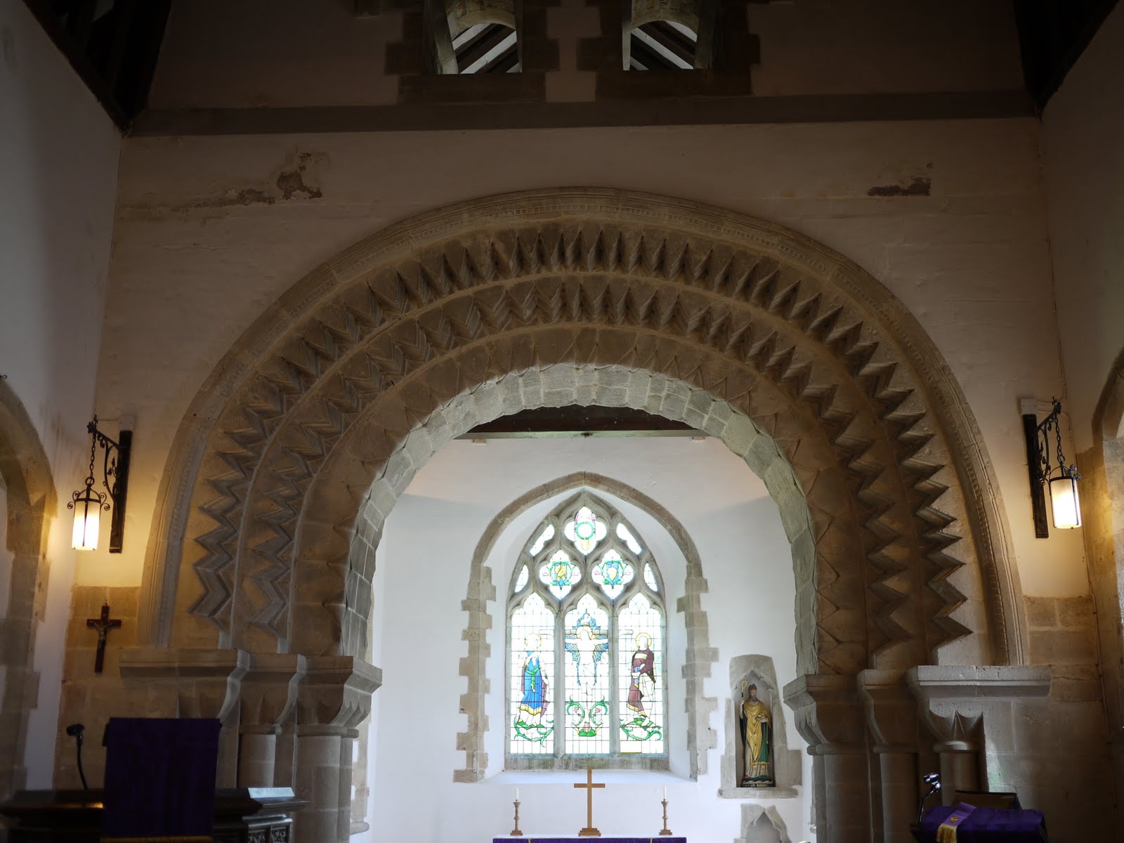
Inside, the magnificent chancel arch, of about the same date (says Pevsner) was apparently brought to the church from elsewhere, probably after the dissolution of the monasteries.


Conditions: sunny, hot.

Distance: about 5 miles, of which only about 1.5 was on the Coast Path. Distance covered now 13.5 miles.

Map: Explorer OL15 (Purbeck and South Dorset).

Rating: four stars.


Sightings

A surprisingly good showing of butterflies: peacock, small tortoiseshell, small white, orange tip, holly blue. We only needed  red admiral, comma, brimstone and speckled wood to have a full set of the butterflies you could reasonably expect to see in early April.


Flower of the day

I haven't been able to identify these delicate blue flowers we saw on the grassy hillside above the coastal path.

Saturday, 19 February 2011

4 Anvil Point to Dancing Ledge

The lighthouse at Anvil Point

On a brief visit to Poole we saw a chance to make a little further progress along the Coast Path. We parked at Durlston Country Park and followed a winding tarmac path down towards Anvil Point to resume our route. According to the Trinity House website, the lighthouse dates from 1881 and was opened by Joseph Chamberlain, father of Prime Minister Neville Chamberlain.

There was a fine view down to the lighthouse as we drew closer. Out to sea the sun broke through the clouds in a few places creating bright circles on the surface: a searchlight from heaven.

Before reaching the lighthouse there is a small preserved stone quarry, with a little four wheeled cart, called a quarr, used to bring the stone up.


We joined the Coast Path, initially walking along a grassy area, but soon joining a narrower and increasingly muddy path. We rapidly formulated a law to the effect that the depth of the mud was inversely proportional to the width of the path - some of the narrow sections were extremely sticky.

This section of the Coast Path is fairly straight, without major features. We went through a National Trust section named Belle Vue, although it did not seem any more belle than the adjoining areas. The first landmark was Blackers Hole and there were by now impressive views along the coast towards St Aldhelm's or St Alban's Head.


Another half a mile or so of struggle through the mud and we came to Dancing Ledge.


We found our way down the ledge itself and noticed that some climbers had descended from there down to sea level to make an assault on the cliff face further along. We naturally had a little dance on the ledge, doing some of our favourite jive moves.

We had planned this walk by reference to the map and now climbed the steep hillside leading to the ridge which runs parallel to the coast along this section - an ascent of about 50m. On the way up we saw our first daisy of the year, which we found strangely cheering. At the top we briefly sat and enjoyed the feeling of the warm sun on our faces - for a moment we felt that we might have been in Nice.

The walk back along the ridge was a delight by comparison with the walk out and we fairly sped along over the short grass. The sky had cleared somewhat and we were surprised by how blue the sea was in places.


The route continued over grassy paths interspersed with dry stone walls.


We reached Round Down and soon returned to the car.

Conditions: cloudy, some sunshine, about 9 degrees; did I mention that it was very muddy underfoot?

Distance: about 5 miles, of which about 2.5 was on the Coast Path. Distance covered now 12 miles.

Map: Explorer OL15 (Purbeck and South Dorset).

Rating: four stars.

Sunday, 6 February 2011

3 Swanage to Anvil Point


Swanage Beach

We used the visit of our friends Judith and Tony to continue our progress along the South West Coast Path. We skipped a couple of suburban streets in New Swanage and picked up the route at the start of the Swanage sea front.

At the end of the sandy beach we passed the curious column with three cannon balls on the top erected by John Mowlem (the founder of the building company) in 1862 to commemorate the defeat of a Danish fleet in 877 in Swanage Bay by King Alfred. This does invite some questions - mainly, why?

We followed the edge of the bay and then detoured to pay our 40p and walk along the Victorian pier. According to Swanage Pier Trust website, "The original Swanage Pier was constructed in 1859/60 by James Walton of London for the Swanage Pier and Tramway Company and opened by John Mowlem. The Pier was built primarily for shipping stone. Horses were used to pull carts along the narrow gauge tramway which ran along the Pier and seafront." We had noticed traces of the railway as we walked around towards the pier. The original pier was found to be too small and was rebuilt in the 1890s.

There is a fine view from the pier towards the Wellington clock tower. There is a wonderful story behind this. It was originally built in 1854 in honour of the Duke of Wellington near London Bridge, but was soon found to be impeding the traffic and taken down. George Burt, a nephew and business partner of John Mowlem, of whom more will be heard shortly, removed the stones to Swanage and rebuilt the tower in its present location. The clock never followed, and a spire was removed in 1904 as it had become unsafe.


We left the pier and continued on our way to pass a pair of Ionic columns, which mark entrance to Prince Albert Gardens. They were apparently date from the early 19th century and were brought to Swanage by John Mowlem, who clearly liked his columns.


A little further on there was a fine view looking back to the pier. Its dog-legged character was more evident from this vantage point.


 We now climbed up to skirt Peveril Point with its lighthouse and continued to climb as we walked along a grassy cliff overlooking the sea. After a short detour along a road we entered Durlston Country Park and walked along a well made path to pass beneath Durlston Castle. The Castle's website explains that it was built as a restaurant by George Burt and was part of his grand plan to create an exclusive housing estate on his land as part of his dream of transforming Swanage into a fashionable resort. The castle is currently under restoration and most of it is hidden under scaffolding.


A little further on, right below the Castle, is the Great Globe, 40 tons of Purbeck stone with a map of the world, nestling in an enclosure in which there are a series of stone plaques carved with quotations from poets and the Bible, as well as facts about the natural world.


We now followed the path above Tilly Whim Caves. (A whim was apparently a type of crane or hoist and Tilly was possibly a quarryman. As just-so stories go, we thought this was pretty weak.) Soon we reached the lighthouse at Anvil Point.


Here we left the Coast Path, turning inland to climb Round Down. From here a grassy track which later joined a road led us down to Swanage High Street, where we saw another wonderful contribution to Swanage's character from the indefatigable George Burt. This is the Town Hall.


It is essentially an unremarkable building to which has been added a superb facade by Sir Christopher Wren no less. Burt rescued it from the Mercers Hall in London's Cheapside.

We now retraced our steps to the start and  enjoyed an excellent lunch at the Ocean Bay restaurant.

Conditions: cloud, drizzle and rain, about 9 degrees.

Distance: about 5.5 miles, of which about 3 was on the Coast Path. Distance covered now 9.5 miles.

From: 50 walks in Dorset (AA) - but from a different starting point and with the sea front element as an addition.

Map: Explorer OL15 (Purbeck and South Dorset).

Rating: four stars.

Wednesday, 26 January 2011

2 Studland Bay to New Swanage

Swanage Bay
   
Flushed with the thrill of Monday's impromptu start of walking the South West Coast Path, we decided to carry on. We parked at the Knoll Beach visitor centre and walked on down the sandy beach (Middle Beach) towards Redend Point, with Old Harry Rocks in sight beyond it.


When the beach ends, you climb a tarmac road and turn left into woodland. The views of the beach through the trees were delightful and - perhaps fancifully - reminded us of the Costa Brava, for example, a walk from Llafranc to Golfet.


Soon, we reached Fort Henry.


It was built in 1943 and is 90ft long with concrete walls 3ft thick. In April 1944, it was the vantage point from which King George VI (now famous for his stammer of course), Winston Churchill, Lord Mountbatten, and Generals Montgomery and Eisenhower watched Operation Smash, a rehearsal for the D-Day landings which took place a couple of months later.

We then walked along Studland's South Beach and then took the path along to Old Harry Rocks at Handfast Point. This involved retracing - in reverse - the wonderful Studland to Old Harry walk we did last October - on which we took some nice photos of the Rocks.

We carried on towards Ballard Point, with a nice view behind us.


 At Ballard Point we descended towards Swanage Bay - see the photo at the head of this post. At the outskirts of Swanage - New Swanage - the path heads inland through a housing development and at this point we followed a path back towards Ballard Down. This climbed steadily until it offered a lovely view of Ballard Down to the right, heading down towards Ballard Point, with the Isle of Wight faintly in view behind it.


Now we began steep, but mercifully diagonal, ascent of Ballard Down proper. After a short while a conveniently located bench offered magnificent views over Swanage. The Victorian pier, on the far side of the bay, was much more noticeable from this height.


We reached the ridge of Ballard Down at the point shown on the map as Stone Seat. Fair enough, there is an aged stone bench, complete with a graffito dated 1852. Poole Harbour can be seen in the background.


We carried on the same direction and followed a path which descended to reach the Norman church of St Nicholas in Studland. We admired the fine chancel arches in the interior.


From here, we headed past the Old Manor Hotel to regain the Coast Path and retrace the last bit of the way to Knoll Beach.

Conditions: cloudy, threat of rain.

Distance: 7 miles, of which 4 were on the Coast Path. Distance covered so far 6.5 miles.

Map: Explorer OL15 (Purbeck and South Dorset).

Rating: Four stars.


Sightings

A nice flock of Brent Geese off Middle Beach on the return leg.


Signs that winter is ending

Catkins on the way to Old Harry Rocks, Vinca in flower by a farmhouse on the way up to Ballard Down, snowdrops in St Nicholas church yard.


Reflections

It was great to be on Ballard Down again and be able to identify all the coastline back to South Haven Point. Of course you could study the map, but there is no better way to get to know an area than to extensively walk it. 

It was also satisfying to do a walk without reference to a walk book. Our dependence on walk books is partly laziness and partly because I am still not very good at calculating distances. Still, our planned approach to the Coast Path will require more of this, which is excellent.