Monday 27 March 2017

87 Hartland Quay to East Titchberry

View south from Hartland Quay

We started this walk from remote Hartland Quay with great views back to the south, albeit into the sun, and ahead to the north.


We 
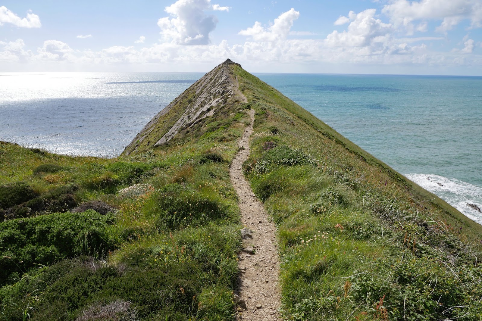
climbed steadily to reach the cliff top and walked along the grassy path. There was a fine view out to sea towards Lundy island.

 
A bit further on there was a very photogenic ruin (of a tower according to the OS map). Off to the right, the church of St Nectan (a new one!) could be seen across the grassy plateau. Apparently the 130 foot tower is the highest in North Devon.


Soon there was a sharp descent to Dyers Lookout, with an attractive valley coming in from the landward side.


Hard on the heels of the corresponding ascent was a further sharp descent to Blegberry Beach, with of course another climb afterwards.


Next up was the rocky Damehole Point. Inland, a long and rather lovely valley ran behind the coastal cliffs. This was a bit unusual – we have seen any amount of valleys running inland at right angles to the sea.


Before long we had our first views of the lighthouse at Hartland Point. It was opened in 1874 and like so many is now automated.


We passed behind it and headed towards the radar dome on the top of a red sandstone cliff above Barley Bay. It was erected in 1994 and is used for air traffic control.


We continued along the cliff top path to Shipload Bay ...


... where we turned inland to reach East Titchberry Farm with its old Malt House clearly in need of some care and attention.


Conditions: bright and sunny.

Distance: 4 miles.

Map: Explorer 126 (Clovelly & Hartland)

Grading: Strenuous.

Rating: Five stars.

Sunday 26 March 2017

86 Morwenstow to Hartland Quay

Henna Cliff

We set out from Morwenstow completing the detour route we encountered yesterday. This meant that we didn't get to see the celebrated Hawker's Hut. (Robert Stephen Hawker, 1803-1875, was the local clergyman, and also an antiquarian and poet. The hut in which he spent many hours writing poems and smoking opium, is mainly of timber construction and is partially built into the hillside with a turf roof. It was originally built from driftwood and timber retrieved from shipwrecks.

When we reached the coast, our first challenge appeared: Henna Cliff, which first required a descent to sea level to Morwenna's Well – a stream in fact, no sign of a well as such. This was followed by a climb to about 140m.

On the way up there was a nice view back to Higher Sharpnose Point, one of the highlights of yesterday's short section.


At the top there was another fine view backwards.


And the coast as far as Hartland Quay and the Hartland lighthouse stretched out ahead.


After a brief section along the cliff top we descended to the curiously named Westcott Wattle 


and climbed the grassy Yeolmouth Cliff. This provided us with a sight of the interesting, but unimaginatively named Gull Rock.


We descended again to Litter Mouth – we now realised that wherever you see the word "mouth" on the map in this part of the world, it denotes the mouth of a river, or more likely a small stream, and you face a descent and immediate ascent. The steps up were quite hard work. At the top we had a fine view of the adjacent Marsland Mouth and Welcombe Mouth.


 Marsland Mouth was especially complicated with the stream following a winding course through deeply indented ground. We were surprised to see a substantial house at the back of the cove.


The climb up was very steep, but did reveal our first butterfly of the day, a Painted Lady. Near the top was Ronald Duncan's hut, a sort of modern version of Parson Hawker. Duncan was, according to an information sheet on the wall a "poet, playwright, journalist, farmer and lover".


There was no respite at the top, simply an immediate descent to Welcome Mouth. This marked the boundary between Cornwall and Devon. 


As we began the ascent out of Welcombe Mouth we took great heart from a sign post telling us that it was now only 4 miles to Hartland Quay. We knew really that it couldn't be right and it actually turned out to be 5.5 miles. This is not the first time a sign post has been wildly inaccurate - how does it come about?

My reading of the map suggested that we would now follow the cliff top for a a good while and this turned out to be right. We started to see more butterflies: Large Skipper, Meadow Brown (the first of the year), Common Blue, another Painted Lady. 

After Emburey Beacon, the terrain began to change and the view ahead showed fields.


At Nabor Point there was a dramatic view of the coast ahead.


But soon we were routed away from the coast and along a road for a short while before again heading back to it along field edge paths. We continued along the cliff top until at Longpeak the path continued inland away from the coast along an inviting valley.


 Here we saw Large and Small Whites and some Green Hairstreaks. This valley met another valley where we turned left towards the lovely Spekes Mill Mouth.


This inevitably triggered another climb after which we passed inalnd of St Catherine's Point with its dramatic triangular rock thrusting up into the sky.


Shortly afterwards Hartland Quay hove into view.


This, finally, was the dramatic view of the coast ahead seen from the Wreckers pub at Hartland Quay. 

Conditions: cloudy at first, later bright and sunny.


Distance: 8.0 miles.


Map: Explorer 126 (Clovelly & Hartland).

Grading: Severe. 


Rating: five stars.

Saturday 25 March 2017

85 Duckpool to Morwenstow

Duckpool Beach and Combe Valley

We have arrived in Cornwall with a plan for three days walking, but immediately had to modify it because we couldn't find a taxi to meet us at the end of the walk we planned. We are staying at the excellent Bush Inn and Morwenstow and fortunately the owner there was able to find us a taxi back to Duckpool.

We set out from there to walk to Morwenstow and climbed the hill to Steeple Point, enjoying a fine view back along the coast of Bude Bay to Bude (we will do this section on Monday before we go home).


At the top of the climb there was a helpful waymark indicating we should turn right rather than throw ourselves over the cliff top. The waymarking on the Coast Path is generally very good, but this one was perhaps superfluous.

The rocky coast stretched ahead …


 … and after a short climb there was an even better back along Combe Valley.


For a while we would mainly walk along the cliff top. And soon we would have our first view of what is marked on the OS map as "Radio Station", but seems to be widely acknowledge as GCHQ Bude.  We emerged onto a grassy plateau and could see the various structures more clearly.


Our taxi driver told us that the round one was covered in Kevlar, one of the functions of which was to prevent interested parties knowing which way the radar dish inside was facing. He said had he learned this on an annual open day.

I was delighted to spot my fourth Painted Lady of the year on this grassy area, but as ever it didn't hang around long enough to be photographed. We were starting to see a few Common Blues and Small Heaths and a few instances of this as-yet unidentified caterpillar.


At Stanbury Mouth we had a sharp descent to sea level and a great view inland.


On the other side, there was a very steep climb, but a great view back at the top over Stanbury and Rane beaches.


Soon there was more excitement with Green Hairstreak number 2 of the year. 


We would also see several Speckled Woods and a lone Small Copper and Large Skipper (the first of the year). Soon afterwards we reached the back of Higher Sharpnose Point. 


The view of the point looking directly out to sea was rather wonderful.


At the back was a semi-ruined hut, presumably once used by the Coastguard. Off to the right was the next high cliff, unnamed on the map, which had clearly suffered some recent rock falls.


We had already been told by some very pleasant local walkers we met that the path was blocked ahead and when we descended to Tidna Shute we weren't surprised to find that here was the blockage point: the cliffs were now regarded as unstable and a diversion inland to Morwenstow was required. We headed inland along the path of the tiny River Tidna, initially in open county and then in woodland. After about half a mile a steep path to the left brought us to the edge of Morwenstow and the pub.

Conditions: Grey at first, becoming bright and sunny.


Distance: 3.5 miles.


Map: Explorer 126 (Clovelly & Hartland)

Grading: Severe. 
Rating: five stars.


Friday 24 March 2017

84 Bude to Duckpool

View of Bude on a nice sunny day

The weather forecast for today's short stage of the Coast Path was pretty dire and we set out from Bude under heavy grey skies, hence the picture above from when we were last here. We started from the famous sea lock and walked across the sand towards the Bude Sea Pool.


It was created in the 1930s as a semi-natural pool, measuring 91m long by 45m wide, fitted under the curve of the cliffs. There were a few brave souls in there this morning, although three out of four of them were wearing wet suits.

We climbed the steps at the back and enjoyed the view back towards the Storm Tower on the opposite cliff.


We soon climbed up to Maer Down and the start of the long run of cliff, broken only by a series of narrow river valleys which extends all the way to Hartland Quay. The tide was out revealing small patches of sand interspersed with large areas of rock. The first headland in the photo is Menachurch Point.


The next section undulates along the grassy cliff top with the same sand and rock combination on the beach. It is beginning to look as though we might be spared the forecast rain.


As we continued along here we saw activity just in front of the two pointed rocks. Two people in red were moving flags on the beach. What were they up to?


As we got closer we realised that they were lifeguards who were demarcating a narrow safe area on the beach at Sandy Mouth. This photo shows the twisting route of the small stream as it makes its way to the sea.


There was a decent climb up from Sandy Mouth and then we were high enough to get our first proper view of the GCHQ operation on the plateau above Steeple Point.


Soon there was another sharp descent and ascent.


And this led to the final slippery descent down to the car park at Duckpool.


Conditions: Grey, with a constant threat of rain. I left my camera behind and used my iPhone for today's pictures.


Distance: 3.7 miles.


Map: Explorer 126 (Clovelly & Hartland)

Grading: Severe. 

 
Rating: four stars.