Lulworth Cove
Much better weather today, so we decided to resume the Coast Path. We parked in the massive public car park at Lulworth and followed many others up the white brick road towards Durdle Door. I have been down this path a couple of times before, but I had been saving going up for an official Coast Path walk. The splendid view you get as you look back is shown above.
At the top you begin the descent towards Durdle Door, with St Oswald's bay in the foreground
I tried a new angle for a photo to try to capture the waves, which were more in evidence than on two previous occasions I had been here this summer (first on 14 April).
After Durdle Door there is almost nobody on the path as it descends further as it passes Scratchy Bottom, a glacial valley. Ahead lies a steep climb to the top of Swyre Head. This is not the Swyre Head which is the highest point along this section of the coast at 203m, and which we encountered earlier in the Coast Path (stage 7 and stage 8, finishing and staring at nearby Rope Lake Head), but another one. It's rather confusing! This one looks high, but is actually only about 100m above sea level.
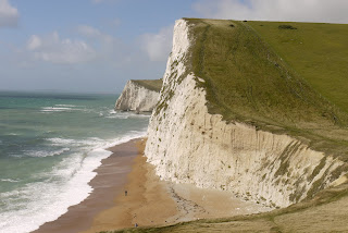
When you get to the top, you are rewarded with great views back.
In the way of the Coast Path you then descend to near sea level and climb up to the top of Bat's Head, from which a new sort of coastline is visible: chalk cliffs still, but less indented and now there is a longer continuation of the beach which starts at Durdle Door.
The path now descends and bit then climbs steadily to pass a navigation obelisk. As you look back, you can see the jagged curve of the cliff edge as it erodes and also the way in which it has been thrown up.
Just before White Nothe we turned sharply right to follow a grassy field edge track which doubles back along a broad grassy ridge parallel to the sea. The views from here are pleasant rather than startling. This is West Bottom.
Further on, you walk on the more dramatic ridge above Scratchy Bottom, and as you descend, there is a good view of the valley itself.
After passing the Caravan Park, we took the inland route back to Lulworth Cove, with the coast fully in view ahead. We now know that the deep dip which is so clearly visible is down to Arish Mell, and we will probably never forget climbing down and up both sides of it in quick succession in the Flower's Barrow to Lulworth section we did prior to today's walk.
Conditions: mainly cloudy, some sunny intervals, extremely windy, mild.
Distance: about 6.75 miles, of which 3 were on the Coast Path. Distance covered now 31 miles.
Map: Explorer OL15 (Purbeck and South Dorset).
Rating: four and a half stars.


