Monday 5 June 2017

98 Ilfracombe to Combe Martin

Ilfracombe from Beacon Point

We start this leg of the Coast Path at the back of the harbour in Ilfracombe. Ilfracombe is an interesting place and I have done a separate post about it. We walked along the landward side of the harbour. The tide was out, but the inner harbour was still attractive.


The outer harbour looked even more bereft.


We then headed up hill along a road and turned left into what felt like a park to emerge at this small cove. We wondered if we had gone the wrong way at first as we couldn't see a path upward (you can in fact just make out a handrail to the left of the concrete shelter. Fortunately a couple of chaps enjoying an early morning can of beer in a sort of belvedere to the left put us straight.


We climbed steeply up from the cove and continued a steady climb through trees and then more open ground over what the map shows as Fort Hillsborough. It seems to be named for an iron age chieftain called Hele. There were lovely views back over Ilfracombe and I used one of then to head my post about Ilfracombe. The best view however came from above Beacon Point (at the head of this post).

Now we descended through woodland along a winding path to finally emerge at Hele. The village was apparently once had a gas works (it closed in 1963) which was for many years supplied with coal by ships which moored at the wooden post which can be seen on the beach.  By the 1950s it had become a popular holiday destination (the coal now being delivered by road) and it was normal to have 200 deckchairs on the beach. And as the photo shows there is a rather tasteful collection of holiday chalets there now. the beach however is more like gravel than proper sand.


We climbed up the hill on a footpath beside the A399 road which continued just the other side of a crash barrier. We eventually took a left which led to the low-lying Rillage Point and then climbed. On the horizon the coast of South Wales stretched out before us.


I spotted a rather lovely Peacock and was quite pleased with this picture taken with the lens I normally use for landscapes and buildings, rather than the usual big zoom.


Soon we had a great view of the west side of Widmouth Head. No doubt we would soon be climbing the steep path on the left hand side.


And so it was. This is the view from the top of the path. In truth it wasn't too bad.


The view east from the highest point of Widmouth Point was wonderful. The narrow cove is called Water Mouth (a bit generic as name, I thought) and the peninsula to the left is The Warren. Hangman Point can be seen in the background. The Great Hangman at 318m is the highest sea cliff in England.


We enjoyed a nice break on Widmouth Point and saw a couple of Painted Ladies, neither of which would pause for a picture. I did get a nice one of a Stonechat however - we have seen lots of them is recent days.


We descended fro Widmouth Head to follow a path through woodland above Water Mouth and emerge opposite Watermouth Castle. This was begin in 1825 but not completed until many year later. It is now a family theme park, although this is not too evident from the road.


A little further on we left the road and walked uphill through a large, but mercifully empty, campsite. We then followed a high level path with at one point a wonderfully beautiful small cove down below. We later saw an access path.


Later the path was diverted so that we had to follow a road for a while as we meandered into Combe Martin. This was our first view. Around the corner is a sandy, but not all that attractive beach.


Conditions: Warm and sunny.

Distance: 5.3 miles.

Map: Explorer 139 (Bideford, Ilfracombe & Barnstaple).

Grading:  Moderate, Strenuous in places.

Rating: four stars.

Sunday 4 June 2017

97 Woolacombe to Ilfracombe

Woolacombe Beach

The tide is out at Woolacombe and it's a bit cloudy, but plenty of people are having fun in the sea and on the enormous beach. We head along the grassy strip to the north of the beach and soon reach a remarkably sheltered little cove which goes by the strange name of Grunta Beach.


After this, the coast is quite rocky towards the next key landmark, Morte Point.


The path heads inland for a while and we climb a hill towards Mortehoe, walking along the road. After a steep climb we turn left to follow the path through a grassy headland towards Morte Point.


We round the rocky point and soon a new vista lays before us to Bull Point with its lighthouse.


This is a very attractive section and we make good progress, descending sharply towards Rockham Bay. We pass inland of Bull Point, which is less interesting up close than from a distance, and the coast stretches out ahead towards Ilfracombe.


We are briefly tempted to think that this will be a brisk cliff top walk when there is a sudden and dramatic descent/ascent at Damagehue Rock.


Soon after there is another at Pensport Rock.


 After this, the coast stretches out towards Lee.


Lee turns out to consist of a small cove with a not very attractive beach and a defunct hotel. However, there is an excellent café where we enjoy welcome refreshments and take a short restorative break from walking. 


Leaving the café we follow a pleasant small road well inland from the sea which climbs steadily for a mile from sea level to 140m above sea. This is the view back. On the horizon is the coast of South Wales, around Milford Haven.


 This gives way to a couple of large fields covered with buttercups and cows. As we approach Ilfracombe, there is an excellent moment as we see our first Painted Lady of the year. Sadly, it didn't wait around long to be photographed. Soon afterwards, an entertaining, slightly grumpy, rusty sign catches our eye


Soon after this there is a moment of great excitement: the first Painted Lady of the year. It just won't wait long enough to be photographed. We pass between two grassy hills


And then we follow the twisting Torrs Path laid out the 19th century to emerge at the edge of the town and follow the road down to just behind the Landmark Theatre where we have a fine view of Capstone Point.


As we follow the path around the Point, there is a nice view of Ilfracombe with the Landmark Theatre on the right.


Once we have fully rounded it, we can see our next challenge, Hillsborough. The harbour, where we ended today's walk, can be glimpsed on the right.


Ilfracombe is an interesting place and I have done a separate post about it.

Conditions: Warm and sunny.

Distance: 7.8 miles.

Map: Explorer 139 (Bideford, Ilfracombe & Barnstaple).

Grading: Strenuous becoming Moderate.

Rating: four and a half stars.

Saturday 3 June 2017

96 Croyde Bay to Woolacombe

Croyde Bay

It's a rather grey morning as we walk away from the northern end of Croyde Sand and it soon starts to rain. The surfers on the beach don't seem to mind however.

Soon there is a fine house overlooking the sea. It is in a sort Charles Rennie Macintosh / art deco style and we can't decide if it is a new build or whether the glass area to the left is a recent addition.


It is certainly an interesting building. Google reveals that it is called Baggy House and is new(-ish) - 1994 in fact and designed by Hudson Architects.  You can see many impressive pictures on their website. Why Baggy House? It is on the peninsular which leads to Baggy Point.

We carry on past this house towards Baggy Point, along a track on a low cliff-top. This is the view back to Croyde Bay. The square shape on the extreme right is a new lighthouse-style house which will allegedly be featured at some point in the future on Grand Designs.


We pass a sign telling us that the land is in the care of the National Trust. Their website has an extract from the North Devon Journal of 11 May 1939: "It is announced that Misses Constance and Florence Hyde of Baggy Point, Croyde, have presented to the Trust the whole of Baggy Point."

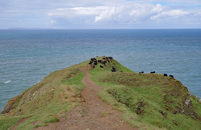
The Point itself– which we were very conscious of when we were walking along the other side of Bideford Bay – turns out to be a low and fairly innocuous headland, currently occupied by a flock of black sheep. The

We climb up over the edge of a hill and soon find ourselves on the other side of the peninsular. This side is Morte Bay and it is immediately noticeable how much calmer and milder it is. The long sandy Beach of Woolacombe Sand can be seen over to the right.


And this is the view back towards Baggy Point.


The southern end of Woolacombe Sand is called Putsborough Sand and this is home to a caravan park, right at the back of the beach.


From this angle, Morte Point, which marks the end of Morte Bay, can be seen to the left.


Our route takes us inland initially as we climb gradually up the hillside behind the beach. After a while we make a sharp descent to emerge on a sandy path behind the dunes at the back of the beach. It's quite pretty with lots of wild rock roses and we see a good number of Stonechats doing their thing from the tops of bushes. But it's odd not to be able to see the sea. Walking on sand is quite hard going too and overall we wish we were had taken a route along the firm sand near the waterline of the beach.  At length we arrive in Woolacombe: undistinguished, but doubtless a good place for a beach holiday.

Conditions: Cloudy, becoming brighter. Mild.

Distance: 6.3 miles.

Map: Explorer 139 (Bideford, Ilfracombe & Barnstaple).

Grading: Moderate.

Rating: three and a half stars.