Showing posts with label Dorset. Show all posts

Friday, 6 April 2012

20 Charmouth to Lyme Regis

 Charmouth

When we started the Coast Path in January last year we thought we might eventually get to Weymouth or perhaps even Lyme Regis. Here we are 15 months later about to do the short leg from Charmouth to Lyme and finish the Dorset section. Basically, we are hooked.

We picked up the route at Charmouth's beach car park and admired the immaculate line of six tastefully-painted beach huts. Then we spent a few minutes locating the departure point of the Coast Path (pass the Visitor Centre on the seaward side and turn half right up the slope), pausing to admire the sweep of the beach.


The route to Lyme is rather odd, involving a long-standing, but erratically signposted, inland route. You walk up from the beach to find the main street, The Street, well-named, and follow this west to turn left on the road to Lyme. Just as you think it may be road all the way, you turn left by the Fernhill Hotel uphill through woods and across a golf course to regain the road much nearer to Lyme. After a bit more road and cutting a corner through a bluebell wood, you descend into Lyme down a grassy hillside. Soon, there is a fine panorama, rather misty today, over the town with the famous Cobb to the right.


You rejoin the  road again to enter the town centre and pass the rather odd-looking church of St Michael the Archangel. There is evidence of Saxon and Norman construction and the nave dates from 1531. The rather unfinished look is due to a restoration of 1933 which was left incomplete due to lack of funds.


Round the corner, the narrow Church Street is closed by the Guildhall, with the Marine Theatre on the left.


And round the corner is the Museum, an exuberant building of 1901, built on the site of the home of pioneer fossil collector Mary Anning, whose life was novelised by Tracy Chevalier in her novel Remarkable creatures. Rather delightfully, the architect was Thomas Philpot, nephew of Elizabeth Philpot who also features strongly in the novel and in Mary Anning's life.


We followed the Coast Path along the back of Marine Parade, detoured for a wonderful celebratory lunch at Hix Oyster and Fish House ...


... and completed our walk by going to the end of the Cobb.


Conditions: cloudy after early-morning rain and never quite managing to clear.

Distance:  3 miles. Distance covered now 86.5 miles.

Map: 116 (Lyme Regis and Bridport).

Rating: three and a half stars.

Wednesday, 4 April 2012

19 Eype Mouth - Golden Cap - Charmouth

Thorncombe Beacon

We returned to the Coast Path after a two month lay-off and picked up the route at Eype Mouth. The path almost immediately begins to climb towards Thorncombe Beacon. There is a sort of brazier at the top (157m) and it turns out that its use as a beacon dates back to 1588 as one of the chain which brought news of the Spanish Armada to London. The beacon was restored in 1989.

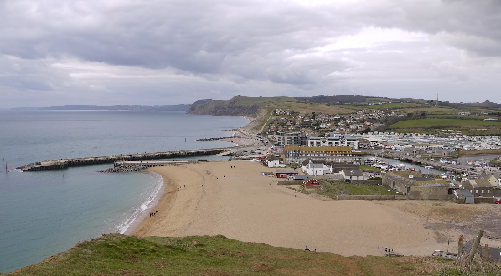
The view back along the beach clearly shows the twin piers of West Bay.


We then descended a little and climbed to the next high point, Doghouse Hill, where the view back dramatically illustrated the extent of erosion on Thorncombe Beacon.


A bit further on we began the descent to Seatown (not to be confused with Seaton, further along the coast in Devon).


Here you are forced a bit inland, along a lane, across a field and through some woodland before the way opens out to Golden Cap, well-known as the highest point on the south coast at 191m. The name derives from the distinctive outcropping of golden greensand rock at the top of the cliff.


When you get to the top there are first of all fine views back to the east, with the beach to both sides of Seatown in the foreground.


One of the nice things about Golden Cap is that the top is quite extensive, so having made the climb up you stroll along a wide flattish area for a couple of hundred yards before you have to descend. Just as you do, there is another fine view to the west over Lyme Bay.


Soon you spot the ruins of St Gabriel's church a few hundred yards inland. It apparently dates back to 1240. This is all that remains of the lost village of Stanton St Gabriel. I have read that the main road was moved a mile and a half inland at some point, because of coastal erosion, and that this was the cause of the village's demise.


Around this point we saw a sign saying 2 miles to Charmouth. This proved to be inaccurate and created  a sense of the final stage of the being an unending series of ups and downs - a pair of later signs showing a mile and half in each direction confirmed our suspicions that it was really three miles. Still, there were many fine views back to Golden Cap.


Also including this one, which dramatically illustrated Tristan Gooley's (author of the Natural Navigator) concept of the "comb-over" effect of prevailing winds on tree growth.


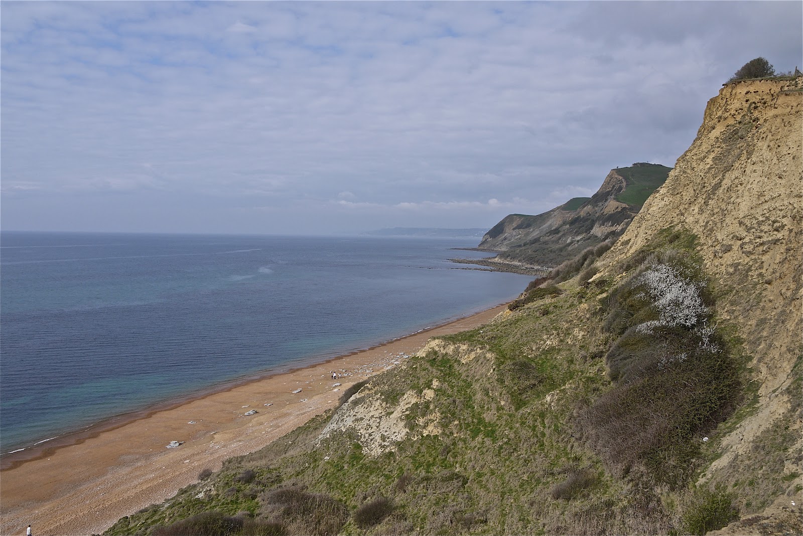
Finally, we gained a good view over Charmouth and Lyme Bay.


We had followed the original line of the coast path all the way, but only right at the end did we discover that it had been diverted inland as the result of a landslip in December 2010. Fortunately for us, people coming from Charmouth had created a desire path at the back of the landslip, so we did not have to retrace our steps. It seems that somebody had missed an opportunity to sign post the diversion. It is very clearly indicated coming out of Charmouth.

Conditions: cloudy, sunny intervals, threat of rain.

Distance:  6.5 miles. Distance covered now 83.5 miles.

Map: 116 (Lyme Regis and Bridport).

Rating: four stars.


Sightings

Three Speckled Woods. And possibly a warbler of some sort - I will have to get my bird DVDs out when I get home. It had a distinctive song, but a drab appearance.

Thursday, 16 February 2012

18 West Bexington to Eype Mouth

Looking west towards Golden Cap

Back in Dorset after a month's gap to resume the SWCP. The last leg (Langton Herring to West Bexington) ended with 2.5 miles along the back of Chesil Beach in a howling wind. Today we start with another 2 or 3 miles until we reach Hive Beach near Burton Bradstock. As the photo above shows, it is fairly unexciting initially - but the enticing prospect of Golden Cap, the highest point on the south coast, can be seen in the distance.

Some interest was provided by Bexington Nature Reserve (Dorset Wildlife Trust), a reedy, wetland. We saw quite a large number of colourful Shelducks here. Then the path leaves the beach and follows the same line across grassy fields behind a line of bushes.

After about 2 miles the path emerges onto a dune behind the beach and begins to climb: you can look down on the beach, gravelly at the back, but with reddish sand at the front.


After passing the first of several holiday-home camps, we descended to Hive Beach, with the famous Hive Beach cafe doing a roaring trade with all the half-term visitors.

We walked down to the shoreline to see and photograph the cliffs with their extraordinary striations. Clearly this marked a transition from the mainly flat coast we have seen since Portland to a new zone of red sandstone. Golden Cap, in the background, is getting closer.


We climbed up, and then walked along, Burton Cliff to descend again to Burton Freshwater, where the tiny and short-lived River Bride reaches the sea (the map shows its source only about three miles away). It is a significant point, because so as we can see, this is the first river we have crossed since we began the Coast Path in Poole, 70-odd miles away.

Burton Freshwater beach is extraordinary. There is a massive gravel slope at the back of the beach, apparently built by the Environment Agency specifically to keep the river flowing smoothly.


You are forced inland here to cross the river and then back along the other bank. It passes through a sort of canyon to reach the sea and it is a fine sight.


Freshwater Bay is dominated by a huge caravan site with a large array of mobile homes at the back of the beach. We spent a moment articulating the difference between mobile homes and caravans and concluded that mobile homes were the ones that weren't in fact mobile - moveable, perhaps.

Now we were really back to classic Coast Path walking. Up the cliff from Freshwater Bay, along a bit, then down a steep slope to nearly sea level, then up again. The crumbling, nearly vertical, East Cliff looks very dramatic.


Bridport was inland to the right and soon West Bay appeared.


Pevsner doesn't have much to say about it, but does reveal that the little harbour is entirely artificial and was first constructed in 1740-4 and was rebuilt in 1824. The fine twin piers are part of sea-defence project and channel the River Brit into the sea.

We had a fantastic fish lunch at the West Bay Hotel. It doesn't look much from the outside, but don't be put off.

We walked past the old Salt House, an early 18th century building once used for storing salt for the Newfoundland fishing trade.


We knew that fishing boats went from Poole to Newfoundland and sold their salted cod in Spain and Portugal on the way back - it was the basis of Poole's prosperity in the 18th century, as evidenced by the fine Georgian houses in the old town. Apparently, a similar trade was carried on from Bridport.

We now climbed the West cliff and soon found ourselves overlooking Eype Mouth where we had left our car. We got a taxi back to the start. I explained that we wanted to be picked up at "ipe" - but was gently corrected - the correct pronunciation is "eep".


Conditions: cloudy, sunny intervals.

Distance: about 7 miles. Distance covered now 77 miles.

Maps: Explorer OL15 (Purbeck and South Dorset) - now completed - and 116 (Lyme Regis and Bridport).

Rating: four stars. The first part was not that interesting, but the stages from Hive Beach were excellent.

Sightings

The most interesting sighting was a Billy Bragg. We knew that he lives somewhere near Burton Bradstock and we were pleased that our paths crossed on a clifftop walk.

Sunday, 22 January 2012

17 Langton Herring to West Bexington

Rodden Hive and The Fleet

Our friends Judith and Tony joined us for today's leg. We did the two car thing (parking one a the end and driving to the start in the other) and starting walking from the centre of Langton Herring, retracing yesterday's path down to pick up the Coast Path by Rodden Hive.

From here, the route heads inland and stays that way until Abbotsbury. We went across fields then up a steadily climbing field-edge path, then across a hillside with fine views towards the South Dorset Ridgeway and Hardy's Monument to the north.  Then up again, to reach a long straight section half-way up a hillside. This we traversed for a mile or so, initially with great views to the south east. The full length of Portland can just about be discerned in the rather hazy distance in this photo.


Soon we could also see the sea, Chesil Bank, the Fleet - in fact the point where it ends - and Abbotsbury's celebrated Swannery.


The path swings just a little to the down to descend into Abbotsbury and the 14th century St Catherine's Chapel - which we had had glimpses of earlier - is revealed in the full glory of its location.


By now the path had become a ridge descending into the valley, with hills all around. A wonderful piece of walking.


We decided to save Abbotsbury's many charms and attractions for a full day's visit later in the year and skirted round Chapel Hill, almost covered, as Pevsner notes, with strip lynchets. The path goes down towards Stavordale Wood, with Abbotsbury sub-tropical Gardens hidden behind it.


Here a sharp left brought us finally back down to the coast. We looked with some anxiety at the path which ran behind the pebbly beach, but was little more than an extension of it. We knew it was 2.5 miles to today's end point at West Bexington. Would it all be like this?


Mercifully, the gravel quite quickly gave way to a tarmaced road and we were able to make good progress. Tony told us that in the 1950s it was possible to drive all along here, but now the road has been downgraded to just serve the few houses found on this rather desolate section of coast and there is nowhere to stop. Traffic is actively discouraged. Seems fine to me.

At the point at which we joined the pebble path, the pebble bank was still quite high, though lower than it had been yesterday. It fairly quickly declined in height and after a mile or a mile and half, it was possible to get a clear view of the now normal-looking beach stretching away to the west.


We finished up with an excellent lunch at the recently refurbished Manor Hotel, West Bexington. It would be well worth going back for the sole purpose of eating here.

Conditions: cloudy, extremely strong wind again, not too cold.

Distance: about 7 miles. Distance covered now 70 miles.

Map: Explorer OL15 (Purbeck and South Dorset).

Rating: four stars.The last part was a bit of a struggle, but the walk down to Abbotsbury was magnificent.

Saturday, 21 January 2012

16 Ferry Bridge to Langton Herring

Oyster beds on The Fleet

Time to begin this year's assault on the Coast Path. Last year we did 56 miles in mainly circular walks, but our target this year is another 70, which will take us into Devon. Our plan is to park at the end of each stage and get a taxi or bus back to the start. Eventually of course we will have to stay in the locality for two or three days at a time.

We picked up the route at the Ferry Bridge pub and immediately walked past the Crab House Cafe, where we had a wonderful lunch on my birthday last year. Soon there is a grassy path, then you cross a little beach to continue on a grassy headland. The Fleet - the lagoon which lies behind the barrier of Chesil Beach - with the Crab House Cafe's oyster beds is alongside. There were lots of dog walkers in this area.

After a detour round an army depot, The Fleet widens out into the area known as Littlesea. There was a nice view ahead, although the red flags indicated that the Army Firing Range at Chickerell was in use, which meant another detour.


At least the detour was extremely well signposted. As we went round we heard and then saw a squad of soldiers returning from the firing range. Do they always have practice on Saturday or were this lot especially poor and requiring extra work?

Soon we passed a pair of crows apparently having a fight to death on the ground. A third crow, perhaps the object of their affections, was nearby. Many other crows were in the air, taking no part. We found this rather disturbing: we don't usually see nature so raw.

We now approached Butterstreet Cove and were increasingly conscious of how this coastline is unlike anything else we have seen in Dorset.


We also reflected on the ever-present gravel bank of Chesil Beach. It is still quite high here and it obscures the sea and foreshortens the horizon. It began to feel like a giant wall keeping us away from the outside world.

After we rounded the grassy headland, we were surprised to see an eclectic collection of buildings at the back of a substantial Georgian mansion.


This it transpired is Moonfleet Manor, now a hotel. As we walked on we saw a quite substantial, if somewhat decayed, wall surrounding the whole site and we could imagine it in its original state.

There followed a very quiet and isolated stretch to eventually reach Rodden Hive, another of the various bays along the back of The Fleet. A signboard revealed that it is major winter roost for water birds.

Now for the final stage up the hill into Langton Herring, past the church of St Peter, with its blocky tower ...


... to reach the Elm Tree Inn, where we were just in time for an excellent lunch. Fish is a speciality and we look forward to going back.

Conditions: fairly clear, extremely strong wind, quite cold.

Distance: about 7 miles. Distance covered now 63 miles.

Map: Explorer OL15 (Purbeck and South Dorset).

Rating: three stars.The Fleet is quite interesting and unusual and a haven for sea birds, but overall probably the least rewarding leg so far.


Sightings

Little Egrets, Widgeon, Redshanks, Brent Geese, Mute Swans.

Friday, 9 December 2011

15 Portland Bill to Ferry Bridge

Portland Bill

Today marks our 15th and final leg of the Coast Path for this year. We picked up the route at the Lobster Pot and walked down behind the light house to Portland Bill itself. The Bill marks the contact point of two different currents: the relative calm to the east contrasts markedly with the the rougher sea to the west.

As you can see from the photo it is marked by an obelisk: it is 23 ft tall and was put there is 1844. The inscription also carries the initials TH - presumably Trinity House. It was apparently installed as a warning of a low shelf of rock extending 30 metres South into the sea.

We passed to the back of the active lighthouse which was built in 1906 and is 35 metres (115 ft) high.


There are two other older lighthouses nearby: one is now a private house and the other is a bird observatory.

Soon afterwards, we passed the fancifully named Pulpit Rock. Apparently it was left after a natural arch was cut away by quarrymen in the 1870s.


The route now crosses a grassy area to reach the west coast proper and then continues along the cliff top. The rocky headland of Blacknor dominates the view.


As you approach it, you pass the soviet era buildings of Southwell Business Park and the village of Weston.

Then there is a curious single-storey round house, quite modern in appearance built right on the cliff top. Our taxi driver on the way into Weymouth told us that the site was once a gun emplacement. The house appeared abandoned. We wondered what the full story was.

Just after this we headed inland to see the church of St George which we had noticed on our taxi ride down to Portland Bill. This striking church is built of Portland stone, as is only proper and has an Italianate feel (the tower and the sort of dome over the crossing), as well as echoes of Wren's London churches in the design of its windows. Our taxi driver thought it was in fact the work of Wren.


Pevsner describes it as the most impressive 18th century church in Dorset (which could be seen as fairly faint praise). He reveals that it was designed and built 1754-66 by a local mason, Thomas Gilbert. "His conception has true grandeur" says Pevsner. We thought that the ends of the transepts were especially dramatic. The church is no longer consecrated and was closed, so we could not see inside.

After this cultural interlude, we returned to the Coast Path and soon found ourselves walking along West Cliff and then above Chesil Cove, where the eponymous beach begins. There were some great views of Chesil Beach.


We descended some steeps steps to reach sea level and were struck by just how steep the beach is. From the landward side, it does appear like a great gravel dune.


That was about it really. We wandered through Chiswell, had a refreshing drink at the pub, and walked the two miles or so back along the causeway, the last part into the face of an icy shower.

Conditions: fairly clear, very strong wind, quite cold.

Distance: about 6 miles. Distance covered now 56 miles.

Map: Explorer OL15 (Purbeck and South Dorset)

Rating: three and a half stars. We preferred this side of Portland.


Reflections

When we started the Coast Path in January, I said that we intended eventually to get to Weymouth or perhaps Lyme. Having already reached Weymouth, we are now beginning to contemplate doing the whole thing. At the current rate of progress, that would take 10.25 more years, by which time we would be into our seventies (ouch!). But as we have now shifted to doing linear rather than circular walks, it should be possible to make faster progress. We are moving towards a goal of completing it by the I am 70, in 2020. How thrilling is that?

Friday, 25 November 2011

14 Ferry Bridge to Portland Bill

The gates of Portland

We had more or less decided to end this year's onslaught on the SWCP at Weymouth, but we saw an opportunity to keep on going, and now we hope to complete the circuit of Portland before Christmas. This would be very satisfying as for a large part of the walk so far, certainly since we turned St Aldhelm's Head, the western horizon has been closed by Portland. It will be great to continue the walk in the new year with open views to the west.

We picked up the route at Ferry Bridge and followed the causeway which links Portland to the mainland for about two miles to reach the gates of Portland above. The gates were funded by the six Masonic Lodges on Portland - a surprisingly large number we thought for a population of around 13,000.

Once on the island proper, we headed for the castle - another of Henry VIII's coastal forts, of 1539 (see also Sandford on the previous leg of this walk and Brownsea Island. This is the landside view.


And below is the view from the shore side. In this view the tunnel entrance to the Verne citadel can be seen near the top of the hillside behind. It was initially a prison for convicts who were employed building Portland harbour in Victorian times and then became a military base; is now a prison again. To left is a large block (I first wrote "blot" - a nice slip) of flats, which had apparently been left unfinished.


The path follows the right side of the hill leading up to The Verne and as we got higher there was an increasingly good view back along Chesil Beach, which starts at Chesil Cove on the west coast of the island and forms the west side of the causeway. It was unfortunately rather hazy.


The route then follows the back of the peak, passing the route of railway lines which were once part of the Portland quarries to come to an entrance to the prison - presumably not the only one! Apparently The Verne, a category C prison (for prisoners who cannot be trusted in open conditions but who are unlikely to try to escape), is known for the large number of separate nationalities which are represented there.


The route now heads east with a "family farm" improbably located on one side and a working quarry on the other.


We then followed the East Weares (which I think means cliffs) and passed the Young Offenders Institution to emerge onto an open grassy area, crossed by quarry tracks which led down to the village of Church Ope. We were struck by Pennsylvania Castle which was built by John Penn, the grandson of the founder of Pennsylvania on land given by his friend King George III (who has been frequently mentioned lately). It is has recently become privately owned, but before that was a hotel.


After a short section of road, the path finally descends to the coast. It is wilder and quieter here and there is a good view back towards towards white chalk cliffs of the south Dorset coast.


This whole area was formerly stone quarries and the evidence is everywhere. We had the rather melancholy feeling of walking through a town that has been devastated by heavy bombing, with piles of rubble all that remained.


There were several of these derricks, which were used for loading stone onto barges.


As we approached Portland Bill along a grassy headland, a whole collection of huts came into view. They looked more like garden sheds than the more typical beach huts you see in Mudeford or Weymouth. But beach huts they are. On the way back to the station our taxi driver told us that they were highly prized and changed hands for "silly money". We had more the sense of a shanty town, but no doubt it all looks different in summer.


Then as one of the three lighthouses loomed ahead and we were fading fast, we saw the Lobster Pot restaurant. At first I thought it could not be open, but we were in luck and enjoyed a reasonable, but extremely welcome meal and a bottle of dodgy sauvignon blanc.


Conditions: cloudy, hazy, mostly quite mild.

Distance: about 8 miles, all forwards on the Coast Path. Distance covered now 50 miles.

Map: Explorer OL15 (Purbeck and South Dorset).

Rating: three and a half stars. Penal settlements, military remains, transport links and industrial archeology dominated the walk. Interesting, but not very pretty.