Monday, 29 April 2013

31 Coleton Fishacre to Dartmouth

Coleton Fishacre

We decided to start our coast walk with a proper look at Coleton Fishacre. It is a 1920s house, built for Rupert and Lady Dorothy D'Oyly Carte by the architect Oswald Milne. It is set high above the coast, with the long valley below made into the beautiful garden for which the house is now especially, and deservedly, known. The interior is in a simple art deco style. Apart from the salon, it is much less grand than might be expected. This is the rear elevation.


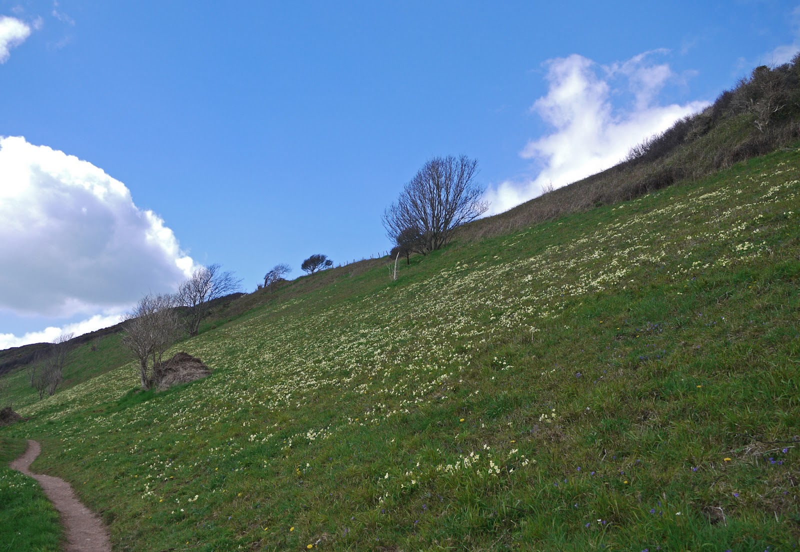
After a very pleasant exploration, we walked down the slope to the back gate we had entered last night and resumed walking. After an initial climb, the path was flat for a while and we were struck by the incredible density of primroses on the hillside.

There was a fine view back to the far side of Pudcombe Cove.


And an even more dramatic one once we reached - after considerable ups and downs - Outer Froward Point.


The offshore rocks - Shooter Rock, Shag Stone and Mew Stone and their nameless companions - were both impressive and threatening.


Once we reached Inner Froward Point we began to see across the mouth of the Dart to a rather different-looking coastline.


Before long, we could see Dartmouth Castle and St Petrox church and the houses of Warfleet on the opposite bank.


Then, on our side. we came upon the Brownstone battery. It was built in 1940 to protect the Dart Estuary, Slapton Sands and Blackpool Sands (which we will pass tomorrow) from invasion. There were two gun emplacements, the other one is higher up, and searchlight stations at sea level. A railway conveyed shells to the gunners.


We climbed to reach the Coastguard station on the top of the point and now entered a wooded area called The Warren where walked on the level for a while, before the next descent and ascent. The route now continued on tarmac, with the estuary below and Kingswear Castle frustratingly hidden from view behind houses and trees.

Eventually we entered Kingswear and reached the Lower Ferry, the end of this leg of coast path, where we had parked our car. The view across to Dartmouth was delightful.


Looking to the right, the vast Royal Naval College dominates the hill.


Pevsner is fairly scathing about the College, the work of Sir Aston Webb in 1899-1905. In his view, it lacks "bombast" and neither the central tower nor the side cupolas are sufficiently imposing. I can only agree.

The Lower Ferry is closed at present so we drove round to the Upper one and made our arrival in Dartmouth. It was too late to start again on the coast path, so we had a little look around. I especially liked these houses, supported on columns - now the town Museum - which date back to 1640.


Next door to our B & B was the Cherub pub, said to date back to 1340 and to be Dartmouth's oldest building.

Finally, I took this evening shot of Kingswear - sadly the sun was temporarily behind clouds, but the light was still lovely.


Conditions: bright and warmer than yesterday, maybe 14 degrees.

Distance: only 3.5 miles along the coast path, but quite hard work. Distance now covered 154.4 miles.

Map: OL 20 South Devon.

Rating: Four stars.

Sunday, 28 April 2013

30 Brixham to Pudcombe Bay/Coleton Fishacre


Brixham harbour

Today we embark on a four day assault on the Coast Path, starting at the breakwater in Brixham and walking up the hill towards Berry Head. Once we were in woodland, we were surrounded by a fabulous display of wild Cyclamen.


We soon became aware of the extensive presence of another plant, this one unfamiliar to us.


It is called Alexanders and is a member of the carrot family. It can be widespread and dense by the coast - as our experience was to testify - but is scarcely seen inland. One byproduct of our recent Cretan flower holiday is that we are trying harder to identify the wildflowers we see on our English walks.

A bit further on you emerge into a grassy area, behind Berry Head itself, where there are two forts built over 200 years ago to defend against attack by Napoleon.


Soon there is a fine view of St Mary's Bay with Sharkham Point on the left.


After passing a holiday village, there is a lovely wooden mermaid overlooking the cliff top. Was she from the prow of a real ship or just a copy? There is something very charming about stumbling on a piece of public art like this.


We wandered around Sharkham Point, bemused by the signposting which had suddenly gone missing, but eventually finding our way. Once at the tip, there is a good view back to Berry Head, with primroses in the foreground.


Looking in the other direction, the next section of coast is laid out before us. The bay with green hills beyond is Man Sands.


The path now winds up to the top of Southdown Cliff, with primroses in profusion along both sides. We walked along the cliff-top (120m), a pleasant break from ups and downs, but soon had to begin the long descent to Man Sands. The isolated Coastguard Cottages are very striking and can been seen from far away.


We had a break for lunch sitting on some comfortable rocks at the back of this spacious beach and climbed back up to the cliff top, now above Long Sands. This is the view back, with Crabrock Point in the foreground and Man Sands partly hidden beyond it.


After a while we descended again, this time to Scabbacombe Sands.


Then it was back up and round Scabbacombe Head, where the coastline began to change. There were no longer higher cliffs which you walked above, but rather a more inclined coastline, where the path was at mid-slope.


The other momentous change which begins somewhere around here is that when you look back you can see only open sea. Previously, you have been able to see the coast of South Devon and Dorset and often as far as Portland.

After quite a few more ups and downs we reached our target for today: Pudcombe Cove (viewed from on high).

We now sneaked through the back gate of the National Trust property, Coleton Fishacre - which we will visit properly tomorrow - and walked up to the road where we met a taxi. Almost inevitably when we went to phone for it there was no mobile signal, but we prevailed on a very kind householder to lend us her landline, which she did very graciously.

Conditions: bright, but cool, maybe 9 degrees.

Distance: 7.5 miles. Distance now covered 150.9 miles.

Map: OL 20 South Devon.

Rating: Four stars. A very flowery walk. Apart from the Cyclamen, Alexanders and Primroses, there were large numbers of Violets, Greater Stitchwort, White Campion and Bluebells, and large areas of Broom.

Sunday, 3 March 2013

29 Paignton to Brixham


 Paignton Harbour

Day 3 of our latest assault on the SWCP. We picked up our route at Paignton's small harbour - much more appealing today at high water. We headed up to Roundham Head and through its pleasant gardens to reach Goodrington, where the waves were quite vigorous against the sea wall.


We climbed up and then descended to cross under the railway line, where there was nice view of south coastline of Tor Bay.


Berry Head can be seen on the extreme left and Brixham is visible to its right. Past a holiday park to arrive at Broadsands Bay where I chatted with a birdwatcher who was leading a birdwatching field trip. I asked what they were watching. "Nothing special" was the reply.  I thought I had seen a few Terns so far on the walk, but he was a bit skeptical. At that point a voice came over the walkie talkie announcing the sighting of a Scoter, a sort of diving duck.

We headed on across the grassy expanse of Cheriton Point, to soon be greeted by the sight of a pair of - yes! - Scoters: black ducks, diving. At the end you come to Ellbery Cove, a pretty spot, famous for a concentration of Seagrass, a great habitat for the likes of Seahorses. The interesting ruin at the right of the cove is the remains of Lord Churston's bath house. Churston was a long-serving MP for South Devon in the 19th century.


We climbed up from the cove to enter Marridge Woods, with Churston Golf Club on the landward side. At the end of this pleasant wooded strip, we emerged at Fishcombe Point, above Churston Cove.


We descended to this delightful cove and as we were climbing up the other side I glanced back and was thrilled to briefly see the dark shape of a seal. It obligingly lifted its head out of the water, but then dived while I was trying to extricate my binoculars.

We we now on the edge of Brixham and as we passed Battery Gardens had a good view towards the Breakwater, close to which we had left our car.


Coming down to the harbour, we were struck by its picturesqueness.


In the centre of the photo is a replica of Drake's ship the Golden Hind. We saw a more famous replica last year in a walk around Southwark.

As we walked round to the Breakwater, I took another shot of the colourful houses that rise above the harbour. 


Conditions: very cold, grey.

Distance: 5.8 miles. Distance now covered 143.4 miles.

Map: OL 20 South Devon.

Rating: Three and a half stars.

Saturday, 2 March 2013

28 Babbacombe to Paignton

Cliff fall at Oddicombe Beach

Day 2 of our latest Coast Path trip. Yesterday we walked from Shaldon to Babbacombe. I had found a walk around Babbacombe on the Royal Geographical Society's  Discovering Britain website and so we started by investigating a house called Babbacombe Cliff. It was not particularly inspiring as a building, but its main claim to fame was that Oscar Wilde wrote A woman of no importance there.


We retraced our steps across the grassy Down in front of the hotel and then went down past the funicular to Oddicombe beach, the site of a major rock fall in 2010. We followed the coast path as it skirted the bay and at sea level got the clearest view of the cliff fall and what it meant: if you look closely at the photo you can that one of the houses on the top of the cliff tragically seems to be missing its whole right side.

Now began the inevitable long climb up from sea level to begin to walk around the series of headlands that separate Babbacombe from Torquay. Pevsner comments on the "exceptionally fortunate geographical situation" of Torquay, which has allowed it to keep "its various parts in attractive isolation from each other".

I thought I had better capture the sturdy new style signs which are in use in this part of the coast path.


We walked across the flat grassy area known as Walls Hill. The Discovering Britain walk guide explains that these flat cliff-top areas are known as "plains"and were formed tens of thousands of years ago when the sea was much higher than it is now: "wave-cut platforms" is the technical name.

We next passed Redgate Beach, closed to the public since 1998 because of falling rock. Apparently there was a local outcry at the time, but no doubt there would have been an even bigger one if someone was killed by a rock slide.

Soon we came to Anstey's Cove, with Devil's Point at its left side. We had noticed these points of rock on our walk yesterday and it seems they are nothing more than bits of a former quarry that proved too difficult to cut. Why not rename them the Dragon's Teeth?


At Black Head there was good view towards Hope's Nose with Ore Stone beyond it.


Now we finally turned the corner of Babbacombe Bay and found ourselves facing the fine sight of Thatcher Rock.


A bit further on, behind Meadfoot beach, we passed an intrusive modern block flats and then came on the Osborne hotel, offering "elegance at modest prices". It is a large Georgian style building with an elegant frieze and fine pediments at either end. It was built as Meadfoot Crescent in 1848 and renamed Hesketh Crescent in 1949. It was very striking how much better it fitted into the environment than the vast modern structure at the other end of this bay. 


Now we climbed to a grassy area (the strangely named Daddyhole Plain) by the Coastguard station where there was this lovely group of presumably early Victorian houses painted in delightful pastel shades - all except the one in the middle.What must the others be saying?


Turning another corner, we began the final approach to the centre of Torquay. The path passed through a delightful folly tower ...


... and descended to pass the Living Coasts coastal zoo. It was a surprise to see penguins on this walk!


Then down to the harbour, past a row of house with lovely iron balconies.


The view across the harbour was very pleasing, with GE Street's St John's church in the background.


Advance study of Pevsner had alerted me to the fact that the church features stained glass by Morris and Co, designed of course by Burne-Jones, who also painted two walls in the chancel. To our intense frustration, it was locked.

Also on the landward side of the harbour was this delightful clock tower. I imagined it must be another Jubilee Clock for Queen Victoria, but it turns out that it was a memorial for Richard Mallock who owned nearby Cockington. It was designed by John Donkin and erected in 1902.


After a break for lunch in Hoopers department store, we headed across to the Pavilion, which dates from 1912 in a mixture of classical and art nouveau styles. It is currently closed, pending re-development.


We walked along the sea front and were struck by the wide expanse of sand.


Set back from the beach is Torre Abbey, dating originally from 1198. After the dissolution of the monasteries the former gatehouse was remodeled into a house and later a Georgian extension was added. This is all closed for restoration at present. To the right is the Tithe Barn, which Pevsner thinks could date to the 13th century. It is a handsome structure.


The last leg of the walk was a plod along the main road, finally relieved by the first glimpse of Paignton.


We followed the road down to the sea front which we followed down past the pier to the small harbour, where we called a halt.


Conditions: cold, grey.

Distance: officially 7 miles, but it seemed rather longer. Distance now covered 137.6 miles.

Map: Explorer 110 (Torquay and Dawlish).

Rating: Four stars.


Sightings

Quite a lot of colour: white bluebells, violets, red campion and this lovely yellow shrub growing in profusion on the slopes as we made our approach towards Torquay.


Friday, 1 March 2013

27 Teignmouth (Shaldon) to Babbacombe

Ferry Beach, Shalford

After a long break, we are back on the South West Coast Path and we pick up the route at Shaldon, across the Teign from Teignmouth, the last place we reached. We are staying in Babbacombe and got a taxi to bring us here to start the walk. We were a bit puzzled when the taxi driver was unable to locate the "place where the ferry arrives", which we had specified as our destination. He eventually dropped us in what he believed was its general location. It turns out it stops just off the beach and the arrival and departure point is marked by a flag and a blackboard. We had expected a jetty.

We walk along the beach and looked across to Teignmouth.


The beach gives way to a path above a sea wall and soon you begin to climb through woods towards the top of the Ness. The view through the trees put me in mind, a touch fancifully no doubt, of similar views in the Costa Brava.


A viewing point at the top of the Ness offered further views back over Teignmouth and the coast back towards Dawlish.

From here, the path continued to climb quite steeply towards Bundle Head and briefly touched the road above Smugglers Cove. The coast here was disfigured by a horrific block of flats in white concrete.

We continued to climb, now above Labrador Bay and soon enjoyed a fine view back.


The next sections of the walk involved a whole series of descents and ascents, mostly without clear views of the sea. We were pleased to come on this more open stretch, with the Ore Stone, an isolated rock beyond Long Quarry Point, visible on the horizon. We enjoyed the yellow broom as well.


A bit further on yet another long ascent awaited, with these steps continuing around the bend at the top of what you can see.


We passed the hamlet of Maidencombe and headed for Watcombe, which has an association with the great Victorian railway engineer, Isambard Kingdom Brunel. He built his retirement home here, Watcombe House (now Brunel House), but sadly never lived in it.

The next feature of note was a rather fetching rock with a hole, with the jagged coastline leading towards Torquay beyond.


Eventually you are forced inland around a golf course to the edge of St Marychurch, but soon you descend again towards the sea to emerge at the edge of Babbacombe by the funicular railway that connects the town to Oddicombe beach. It is a steep descent.


We departed the coast path here to walk up Babbacombe Downs to return to our hotel, passing the funicular station on the way, its carriage parked for the night. The railway dates back to 1925.


Conditions: cold, grey.

Distance: 6.4 miles. Distance now covered 130.3 miles.

Map: Explorer 110 (Torquay and Dawlish).

Rating: Three stars.

Sightings

We saw several buzzards being mobbed by crows. There is nothing unusual in this of course, but it seemed at that any individual crow felt it was his duty to mob any passing buzzard. Apparently it only takes one to be a mob.