Friday, 1 March 2013

27 Teignmouth (Shaldon) to Babbacombe

Ferry Beach, Shalford

After a long break, we are back on the South West Coast Path and we pick up the route at Shaldon, across the Teign from Teignmouth, the last place we reached. We are staying in Babbacombe and got a taxi to bring us here to start the walk. We were a bit puzzled when the taxi driver was unable to locate the "place where the ferry arrives", which we had specified as our destination. He eventually dropped us in what he believed was its general location. It turns out it stops just off the beach and the arrival and departure point is marked by a flag and a blackboard. We had expected a jetty.

We walk along the beach and looked across to Teignmouth.


The beach gives way to a path above a sea wall and soon you begin to climb through woods towards the top of the Ness. The view through the trees put me in mind, a touch fancifully no doubt, of similar views in the Costa Brava.


A viewing point at the top of the Ness offered further views back over Teignmouth and the coast back towards Dawlish.

From here, the path continued to climb quite steeply towards Bundle Head and briefly touched the road above Smugglers Cove. The coast here was disfigured by a horrific block of flats in white concrete.

We continued to climb, now above Labrador Bay and soon enjoyed a fine view back.


The next sections of the walk involved a whole series of descents and ascents, mostly without clear views of the sea. We were pleased to come on this more open stretch, with the Ore Stone, an isolated rock beyond Long Quarry Point, visible on the horizon. We enjoyed the yellow broom as well.


A bit further on yet another long ascent awaited, with these steps continuing around the bend at the top of what you can see.


We passed the hamlet of Maidencombe and headed for Watcombe, which has an association with the great Victorian railway engineer, Isambard Kingdom Brunel. He built his retirement home here, Watcombe House (now Brunel House), but sadly never lived in it.

The next feature of note was a rather fetching rock with a hole, with the jagged coastline leading towards Torquay beyond.


Eventually you are forced inland around a golf course to the edge of St Marychurch, but soon you descend again towards the sea to emerge at the edge of Babbacombe by the funicular railway that connects the town to Oddicombe beach. It is a steep descent.


We departed the coast path here to walk up Babbacombe Downs to return to our hotel, passing the funicular station on the way, its carriage parked for the night. The railway dates back to 1925.


Conditions: cold, grey.

Distance: 6.4 miles. Distance now covered 130.3 miles.

Map: Explorer 110 (Torquay and Dawlish).

Rating: Three stars.

Sightings

We saw several buzzards being mobbed by crows. There is nothing unusual in this of course, but it seemed at that any individual crow felt it was his duty to mob any passing buzzard. Apparently it only takes one to be a mob.

Sunday, 30 September 2012

26 Exmouth (Starcross) to Teignmouth

Exmouth from Starcross

The third day of our latest SWCP trip. We finished up last night at the ferry in Exmouth, so today we drove round to the other side, Starcross, and set off from there. The first two miles just follow the road (the A379 from Starcross to Cockwood and then a minor road) down to Dawlish Warren. As we approached this well-known holiday area, we were staggered by the number of holiday parks on either side of the road.

We wondered about going to see the nature reserve, but decided to press on, joining the path along the sea wall just by Dawlish Warren station. Signs warned that the sea wall route could be dangerous at high tide, but mercifully it was close to low water.

Quite soon, you see Cowhole Rock. I have scrupulously framed the photo to avoid the Red Rock cafe, the busy path and the railway, all of which are off to the right.


Once past the rock, you walk between the sea on the left and Brunel's extraordinary railway line, with red sandstone cliffs to its right.


It was interesting to see from close up how almost liquid the sandstone looks and how eroded it is.


Gradually the path comes nearer to sea level and you pass a series of groynes. Hole Head stands at the end of the bay.


After four miles of hard path we took a break for refreshments in Dawlish. As we left the town and climbed up to Lea Hill, we were surprised to see quite a lot of people positioned on the railway bridge and higher up, many with cameras, tripods, the works. We found out that they were all in place to see a steam train pass by which was expected in 30 minutes or so.  A quick Google search reveals that this service, run by Steam Dreams, is pulled not by the usual restored old steam locomotive, but by a new replica called the Tornado built by a group of enthusiasts .

We carried on and instead took a nice picture of the curve of Dawlish Beach leading up to the Langstone Rock. The wave patterns made an interesting sight.


After Lea Hill, there was a section of road, then we turned left to see - what joy! - a normal section of coast. I include the photo only to remember the sense of relief we felt. 


As we were descending towards the right, we heard the whistle of the steam engine, which is, it must be said, a wonderful nostalgic sound. I was quite pleased with this impromptu shot, taken by pointing vaguely in the right direction and focusing by guesswork. No doubt the people in Dawlish did much better.


After a steep climb with further views over Dawlish and another brief section along the road, we reached the sea wall by Shag Rock and followed it along, above the beach, to Teignmouth.

The seafront at Teignmouth presents a mainly 19th century face to the world. The symmetrical and harmonious blocks of hotels date from the 1820s (although some had to be rebuilt after damage during the war), while the pier dates from 1865.


The nearby lighthouse dates from 1845 and at 6m is probably one of the smallest you are likely to see, but its static red light still performs a useful function guiding boats through the mouth of the Teign to the harbour beyond.


The curious wheels attached to the lighthouse are a contribution to the 2012 Sculpture Trail: Spinning Flowers by Imel Sierra Cabrera.

The walk ended, as it had begun, with a view across a river estuary from a ferry point, this time in Teignmouth Harbour looking across to Shaldon. All that remained was to get a taxi back to Starcross.


Conditions: cooler than of late and very cloudy.

Distance: 8 miles. Distance now covered 124 miles.

Map: Explorer 115 (Exmouth and Sidmouth).

Rating: three stars. We felt that this was the least enjoyable leg so far, as it was almost entirely on made up paths. There were many interesting aspects however.

Saturday, 29 September 2012

25 Buddleigh Salterton to Exmouth

The west end of Buddleigh Salterton beach

Refreshed after an excellent dinner at Tobias restaurant and a good night's sleep, we awoke to a lovely sunny day and set out reasonably early to walk to Exmouth.

We didn't, sadly, get to see East Buddleigh, where Sir Walter Raleigh was born and where Millais traveled to paint The Boyhood of Raleigh.

The west end of the beach, with yet more red sandstone cliffs looked lovely in the morning light. The red cliff along this section of coast are variously described as being 200 or 250 million years old. The beach at Buddleigh is interesting, being formed of smooth flattened oval pebbles, some quite large.

We chatted to a man who had just bought fresh plaice and brill from a fisherman on the beach, and seemed appropriately happy about it. As we followed the path upwards, a fine view of the whole beach looking eastwards became visible.


The path crossed a level grassy area and then began to climb through heathland. Helpfully positioned benches offered ever more wonderful views back to the east.


At Littleham Cove we encountered the first of two closely located holiday parks, but the views back along the coast were exquisite.


We crossed the headland behind Straight Point (isn't that a bit of a contradiction in terms?), forced inland by the existence of an MOD firing range, to skirt another, even more massive holiday park behind the very reasonably named Sandy Bay.


This was interesting for its depth and shallowness - and for its yellow sand. We watched people taking a brisk stroll along the beach and round the corner to Orcombe Point, then back along the Coast path.

At Orcombe Point, which marks the end of the Jurassic Coast we saw the impressive Geoneedle, with Exmouth in the background.


This area is also the oldest part of the Jurassic Coast. The Geoneedle contains nine different stones found along this coast embedded into a frame of Portland Stone and was unveiled in 2002. It was commissioned from the artist Michael Fairfax to mark the recognition of the Jurassic Coast as a World Heritage Site by UNESCO.

We soon descended from the cliff top to reach sea level and then followed a promenade for the best part of two miles into Exmouth. The white facades of its hotels stood proudly by the wide mouth of the river Exe.


As we approached the centre we came on the modest Jubilee Clock of 1887.


We thought it similar to the one back up the coast in Seaton.

Finally, we reached the ferry across the Exe and the nearby marina, where we were really taken by the varied and brightly coloured apartments.


Conditions: sunny, warm.

Distance: 6 miles. Distance now covered 116 miles.

Map: Explorer 115 (Exmouth and Sidmouth).

Rating: four stars. Some great photographic opportunities.


Reflections

One odd and rather annoying feature of this walk was that although it was very well signposted, the distances on the signposts were wildly inconsistent. At the outset we saw a sign saying Exmouth 4m. This surprised us because the SWCP guide describes this section as 6 miles. After a while we began to see signs pointing in each direction: Buddleigh 2 / Exmouth 2. But then all of a sudden, half a mile later Buddleigh 2 1/2 / Exmouth 2 1/2. We even found a combination adding up to 5 1/4. Then later it was back to 4m. From the time taken and my pedometer reading we are pretty sure that it was in fact 6 miles to the Starcross Ferry.

Having said that, I must say that in general East Devon council are doing a grand job of signposting. There is always one when you need it and most, if not all, have the grid reference on a white label: invaluable if you know where you are going, but are not sure where you are.


Flower of the day

What is this ubiquitous yellow flower?


Butterfly of the day

We saw lots of seemingly freshly-minted Red Admirals. This one offered the rare opportunity of a photo of the underwings from below as it basked on an ivy flower.


Friday, 28 September 2012

24 Sidmouth to Buddleigh Salterton

The east end of Sidmouth beach

The start of another three-day assault on the Coast Path and we pick up the route at the east end of Sidmouth beach, in front of the terrace of early Victorian hotels. We walked along the promenade and
followed the Millenium walkway around the headland.


On the other side was another fine beach with characteristic red sandstone cliffs.


We began the long climb to Peak Hill and looked back to see the curious structure known as Jacobs Ladder which leads up to the Connaught Gardens, dating back to 1820.


Further up the steep grassy slope, there was a fine view back over Sidmouth and the coast to the east.


Once we reached Peak Hill, after a reasonably steep climb, the path leveled out and ahead lay the sea stacks known as Big Picket Rock and - yes!- Little Picket Rock.


Inland there were lovely views across open country.


Soon there was an even more impressive view back to Sidmouth.


The sea stacks at Ladram Bay reminded us of Old Harry rocks as we approached.


And after we had skirted the seemingly inevitable holiday park, there were even more wonderful sights, which I found very difficult to satisfactorily photograph. This was the best I could manage.


The route the cliff tops until we began the descent beside and then across fields into Buddleigh Salterton. A fine stand of pine trees marked the end of forward progress along the coast.


We now followed the River Otter inland for about a kilometre, crossed a little bridge and followed the other bank through the Otter Estuary Nature Reserve. It was beginning to get dark and our energy was fading too, but we did spot a couple of Little Egrets in the wide river mouth.


We walked along the promenade and into Buddleigh to the Feathers pub where we were staying. On the way we passed the Fairlynch Museum, housed in a lovely thatched house of 1811.


It is apparently one of the few thatched museums in the country.

Conditions: cloudy with a threat of rain.

Distance: 7 miles. Distance now covered 110 miles.

Map: Explorer 115 (Exmouth and Sidmouth).

Rating: four stars. Mainly for Ladram Bay.


Flower of the day

We spotted this lovely flower alone by the side of the Otter. Again, what is it?


Wednesday, 8 August 2012

23 Branscombe to Sidmouth

Looking west towards Sidmouth

Day 3 of our Coast Walking trip to Devon. We drove to Branscombe, where we left off yesterday, parked outside the church and climbed up to rejoin the coast path. We fairly soon emerged out of the woods, passed a couple of parked cars (how did they get there? should we have done the same?) and reached the open cliff top (Berry Cliff) with the first, rather hazy, views towards Sidmouth - today's destination.

A bit further on, the view became a little clearer, and we could make out the long sweep of coast from Sidmouth down to Otterton Ledge and the mouth of the Axe beyond, with Torbay further in the distance.


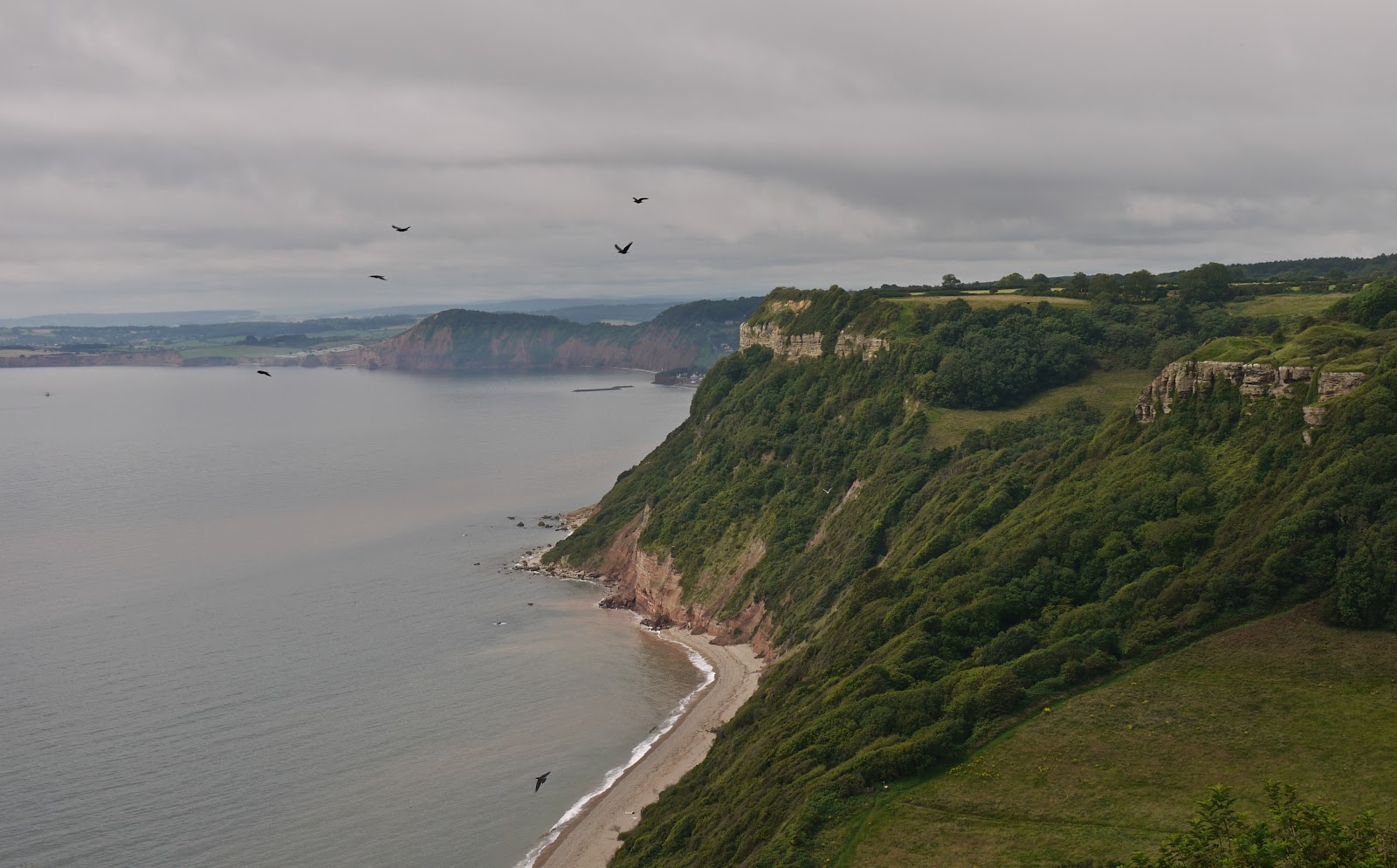
There followed a flat grassy section above Littleton Shoot, with more mysteriously parked cars, and the we could see the pebble beach of Weston Mouth, the first major descent on the walk - and the equally major climb waiting on the other side. The birds in the photo are ravens, which roost in the undercliff. We saw one quite close up sitting on a fence post and were impressed with its size.


The path takes you down right to the back of the beach, across the mouth of a pretty stream ...


 ... and through fields up the edge of the opposite cliff. We were very pleased to emerge a bit later on to Lower Dunscombe Cliff, a pleasantly undulating area, with hillocks covered in wild flowers and butterflies. The cliff itself was rugged and eroding.


After a short detour inland at Linchcombe, Higher Dunscombe Cliff was flatter and more agricultural than its Lower neighbour. The first clear view of Sidmouth opened up as we approached Salcombe Mouth, the second major descent/ascent.


This time at least it wasn't necessary to go right down to the sea before beginning to climb again. The view looking back to Higher Duncombe Cliffs and the shoreline below from the hill west of Salcombe Mouth was dramatic. It is a bit puzzling that this dramatic viewpoint doesn't seem to have a name.


Now we walked along Salcombe Hill Cliff and emerged to find a simply wonderful viewpoint over the town and its two bays.


A final winding, but quite gentle, descent, by comparison with the others, brought us to Sidmouth esplanade. The terraces with their verandahs date from 1837.


The Sidmouth Folk Festival was on, unbeknown to us, and the town was very busy. It look a little while to find a quiet pub for a recuperative drink and we decided to put off exploring until next time.

Conditions: cloudy for the most part, but warm.

Distance: 5 miles. Distance covered now 103 miles.

Map: Explorer 115 (Exmouth and Sidmouth).

Rating: four stars. Arduous, but rewarding.


Butterfly of the day

Quite a good day for butterflies. Lots of Meadow Browns and the odd Admiral, white and Fritillary. The signature butterfly however was the Gatekeeper. The photograph doesn't quite do justice to the intensity of the orange.