Sunday, 21 August 2011

10 Flower's Barrow to Lulworth Cove

Worborrow Bay from Flower's Barrow

We decided to carry on where we left off yesterday at Flower's Barrow. Our circular walk approach to the SWCP meant that essentially we had to do a there-and-back walk from Lulworth Cove, as there was no other sensible start point and a very limited choice of alternative paths. 

We set off from the tourist car park and walked down the sloping street to the Cove itself, taking the stairs on the left to climb the hill above the cove. At the top we headed on up the very steep hill to find the start of the path which follows the ridge parallel to the coast. This chalky hill is a fine butterfly site and we saw several Chalkhill and Adonis Blues.

Soon we entered the Army Ranges, noticing as we did two squaddies with massive backpacks who were presumably out on some sort of punishment run.  
We headed along the stony, chalky track past what seemed to be a massive TV aerial, enjoying fine views to the north and, from this point on, the sight of a tremendous sweep of coastline from St Aldhelm's Head in the east to Swyre Head and Portland in the west. To the left, inland, the Lulworth Army camp and training ground stretched out with a large network of tracks and sundry wrecked and rusty tanks scattered across it.


We walked along the top of Bindon Hill, with the long slope leading up to Flower's Barrow all too visible in front of us. We saw a number of Wall Browns here basking in the sunshine.


We thought the ridge continued all the way, but first there is a steep descent to Arish Mell at sea level. The little beach here is closed and a crew of workmen doing something with what seemed to be an outlet of some sort. A Google search yielded a suggestion that there was once an outlet here from the Winfrith Atomic Energy Establishment. So perhaps it is being repaired.

On the other side, a long winding slope led steeply up to Flower's Barrow. Once we were there, the view back along the coast was superb. 


Now we began this leg of the Coast Path in the correct direction! Walking down the long slope was actually more taxing than climbing it had been. The toes and knees complained loudly. Then it was straight back up the other side to the ridge leading to Bindon Hill.

The views forward over Mupe Bay, with Mupe Rocks behind were very fine. 


As we descended Bindon Hill towards Mupe Bay, the chalk cliffs provided an impressive sight along the coastline.


At the bottom, we went to the corner of the small bay housing Mupe Rocks and puzzled over the extraordinary angle at which the strata of rock were pointing.


There was now a flat section along a grassy cliff-top path overlooking the Fossil Forest. This is a literal description rather than a fanciful one. 144m years ago there was a forest here which was flooded under a shallow, saline lagoon. Thick mats of algae grew across the forest floor and around the base of the trees and fallen logs.  Sediment stuck to the this and built up over time to form the large doughnut-shaped rings that can be seen today around the trees and wood.

At the end of this section you reach the mouth of Lulworth Cove, with Portland and Weymouth in sight beyond.


We climbed the long sequence of steps to the side of the cove and walked along the lower path at the top enjoying a fine view of the cove.


Then it was down the path and steps on the other side to walk back up the lane to the car - via a well-deserved drink in a bar on the way.

Conditions: sunny, hot.

Distance: about 7 miles, of which only 3 were on the Coast Path. Distance covered now 28 miles.

Map: Explorer OL15 (Purbeck and South Dorset).

Rating: four and a half stars.


Reflections

The walk took us far longer than a walk of this length normally would. Obviously this was due to the five steep climbs or descents that it included - and the consequent rests that they entailed. It led us to think that we need a better way of estimating the time required for this sort of walk and I remembered my friend John once saying that with Alpine walking the total change of height was often a better predictor of time taken than the linear distance. In this case the eight climbs/descents amounted to over a kilometer of change of level.

Secondly, I realised that I still need to improve my map-reading skills in order to identify all these changes in advance, rather than be surprised by them.

When we looked in the SWCP Handbook we were delighted to see that the Lulworth to Kimmeridge section was rated "Severe" - the highest rating on a scale starting at "Easy". Who would have thought we could have handled Severe without any great difficulty?

Saturday, 20 August 2011

9 Kimmeridge to Worbarrow Bay and Flower's Barrow

Worbarrow Bay

We picked up the SWCP at Kimmeridge, keen to get through the section which goes through the MOD Lulworth Ranges while they are open in August. We left Kimmeridge along the road, passed the BP "Nodding Donkey" Oil Well and entered the MOD land through the gate, pleased to be wished "Happy walking" - not like the MOD of old!

You walk along a broad grassy path with two of the Kimmeridge ledges, Broad Bench and Long Ebb, below. Hobarrow Bay lies between them and is succeeded by Brandy Bay. The Gad Cliff is in view ahead (see below) as you swing inland to climb towards and then pass beneath the large grassy hill of Tyneham Cap.


At about this point we encountered the advance guard of the heroic runners racing from Weymouth to Swanage (32 miles!). We would see many more in various states of fitness as our walk progressed.

As we walked along Gad Cliff there was a fine view back along the coast with the two ledges clearly displayed and St Aldhelm's head dimly visible in the background.


You then walk along Gold Down to reach the high ground above Worbarrow Bay. As you descend the large mound on the nearside of the bay becomes clearly visible. This is Worbarrow Tout - tout is an old word for a lookout point.


You descend right to sea level at the back of the beach and as you approach it there is a great view of the wide expanse of the bay.


Now the path climbs right to the top of the hill to reach Flower's Barrow. It could clearly be seen to become ever steeper the nearer you get to the top.


Still, after a quite strenuous climb the view back over Worbarrow Bay and Tout was very impressive.


We now left the Coast Path for today and turned inland along a ridge. This is the end of the Purbeck Ridge which runs in a grands curve from Ballard Point via Corfe Castle to here. The main views are inland to the north. It is mainly flat, but Lulworth Castle provides a focal point.


After a mile or so, we left this track and took a path downhill to pass through Tyneham, the celebrated deserted village. It was taken over by the Army in 1944 for rehearsals for the D Day landings and retained in MOD ownership after the war.

There is not a lot there but some of the main buildings, including the restored church, are clearly visible as you approach.

The old telephone box looked suitably nostalgic.


From here, we followed a grassy path zig-zagging up to rejoin the coastal path above Gad Cliff and retraced our steps to Kimmeridge Bay. 

Conditions: cloudy, hot.

Distance: about 7 miles, of which about 3.5 were on the Coast path. Distance covered now 24.5 miles.

Map: Explorer OL15 (Purbeck and South Dorset).

Rating: four stars.


Flower of the day

I saw this rather wonderful yellow poppy-like flower on the incline above Brandy Bay. Frustratingly, I have been unable to identify it.


Sunday, 24 July 2011

8 Rope Lake Head to Kimmeridge

View over Kimmeridge

After another month's gap we continue our slow progress along the SW Coast Path. We decided to park on the cliff in Kimmeridge Bay, which would be the end point of the walk. This meant in effect repeating a walk from Kingston to Kimmeridge which we did in January - but in reverse and with a different starting point. We started therefore by walking inland up to an through Kimmeridge village, past the church and up the road. This offered increasingly fine view back over the village and the bay.
At this point we made a further climb up to the top of the steep ridge which overlooks Kimmeridge and more less follows the line of the coast to the east. The map shows this as Smedmore Hill and although the contour lines are hard to read, it is clearly about 200m above sea level - so a pretty decent climb from where we had started.

The views from the ridge were excellent, and as we neared Swyre Head there were also fine views inland to the north west. Here is Swyre Head, with the sea behind, seen from the ridge.


We had climbed Swyre Head (203m) on the previous leg of the Coast Path and on January's walk and we were rather looking forward to going down it for a change. It was indeed much easier, but still quite hard on the knees. However, the fine views to the west were a compensation.


Having by now walked four miles, we started on the Coast Path itself. This is an undramatic section, with the Kimmeridge Ledges (limestone) being the most notable feature.


As we approached Kimmeridge, the Clavell Tower folly, the other highlight, presented itself for our inspection (its story is described in January's post).


,

Just past the folly, you begin the descent to Kimmeridge Bay, with the westward continuation of the Smedmore Hill ridge in view behind it.


Conditions: sunny, hot.

Distance: about 6 miles, of which only 2 were on the Coast path. Distance covered now 21 miles.

Map: Explorer OL15 (Purbeck and South Dorset).

Rating: four stars.


Sightings

I think this lovely pink flower may be Red Soapwort, but I am not completely sure. I could not definitively locate it in my wild flower books.

Tuesday, 14 June 2011

7 Chapman's Pool to Rope Lake Head

Looking back towards St Aldhelm's Head

After a two months' gap, today offered an opportunity to resume our progress, by means of circular walks, along the South West Coast Path. We started at a car park to the west of Kingston, just by the entrance to Encombe Park, and walked back along the lane to the village. There were fine views to the left towards Corfe Castle. You could very clearly see the way in which the castle perches on a self-contained hill, with the Purbeck ridge rising on either side of it. What led to the interruption of the ridge?


In Kingston, we turned visited the church of St James and then turned right towards the sea. We were pleased to immediately identify it as Victorian. It turns out to be by the eminent architect G E Street  and was built in the 1870s, lavishly funded by the third Earl of Eldon. Pevsner describes it as his (Street's) "grandest church in the country".


We followed the road due south as it gradually became a track. After about a kilometre, we forked left on a permissive path aiming for the precise point at which we left the Coastal Path in April. We were pleased to find it successfully, but something went slightly awry because we had to carefully climb over a barbed wire fence at the end.

The path is a long way inland here, forced away from the coast by the steep ravine at the back of Chapman's Pool. As we walked along we could see the rocky side of Emmetts Hill, and remembered the many steps we had climbed up to reach it on the last leg from Winspit to Chapman's Pool.


Soon the path opened out into a wide glacial valley as we curved round under a fine rounded, but seemingly unnamed, hill 136m above sea level. When then took a path on the left, leading right down to the coast. This is the view back.


Now we climbed this leg's set of steps: about 200 of them leading up to the top of Houns Tout cliff, at 140m. The view back towards Chapman's Pool and St Aldhelm's head was exhilarating.


We were delighted to find a sun-warmed stone bench looking west and sat there for a while taking a breather and enjoying the view towards Rope Lake Head - the second headland in the picture, the first is Egmont Bight.


There now followed a long descent and then a relatively flat section, with Swyre Head, the highest point along the Dorset coast at 203m, rising to the right.


Just before Rope Lake Head, we took the path which leads, over a kilometer or so of steady climbing, to the top of Swyre Head. We came this way in January walking from Kimmeridge, to the west, so we knew exactly what to expect. Last time, it had been raining and the slippery mud added considerably to the difficulty. Today it was dry, but still a decent climb.

As we approached the top, with a hint of early sunset, the view to the west towards Kimmeridge Bay opened up.


The final stage back to the car park followed the line of the ridge overlooking the stretch of coast we had just walked along. The curve of the ridge mirrored the curve of the coastline. In the valley below Encombe House nestled, almost invisibly, in its private park.

Conditions: sunny, hot.

Distance: about 6 miles, of which about about 3 was on the Coast Path. Distance covered now 19 miles.

Map: Explorer OL15 (Purbeck and South Dorset)

Rating: four and a half stars


Sightings

Quite a good day for butterflies: Large and Small White, Meadow Brown, Small Heath, Small Tortoiseshell, Speckled Wood, Painted Lady (our first of the year), Large Skipper, and two Blues - I think Silver Studded and Adonis.

On the bird front, we watched a Kestrel circling around the cliff edge at Houn's Tout and admired the gliding flight of a number of Fulmars. Later we saw a small flock of Goldfinches and a pair of Yellowhammers. The highlight though was to definitively identify some Stonechats: a male, a female and a chick.


Flower of the day

This Viper's Bugloss grew in a number of places on the top of Houn's Tout. I have had it as my Flower of the Day before, but never in such a dramatic location.


Friday, 15 April 2011

6 Winspit to Chapman's Pool

Winspit

We took the opportunity of the visit of my friend John to continue the Coast Path. Like the last leg (Dancing Ledge to Winspit), we started from Worth Matravers and walked down the long ravine that we had walked up at the end of previous walk.


When we reached Winspit, we climbed the steep stairs to reach the clifftop at West Man, and looked back to East Man on the other side of the ravine.

As we walked along the path we gradually became aware of a line of disturbance in the sea, as it changed from being seemingly still on top to being quite turbulent. We could also hear an increasing amount of noise. As we got closer we could see that the apparently calm water was in fact flowing west at quite a fast rate.

 
What was going on? It is apparently the result of a Portland stone ridge which stretches out to sea about 50 ft below the water level.

As we approached St Aldhelm's Head, we passed the memorial to the radar research carried out at Worth Matravers during 1940-42.


It was erected only in 2001 and is the work of a local sculptor, Tony Viney. The full story can be found on this website, which answers the obvious question: Why only 1940-42? It was discovered that the Germans, who were also working on radar, were planning a commando raid and so the work was moved to safety inland.

A little further on we came to the famous St Aldhelm's chapel.


This is an extraordinary little structure. It is square with one massive column in the centre supporting four vaults which hold up the roof and divide the space into four. There is an altar in the corner opposite to the doorway lit by a small lancet window. It dates from about 1100, but looks like no other church I have ever seen. It is unlike a normal church in that the four corners are oriented towards the cardinal points of the compass, whereas churches are normally oriented along an east-west axis, unless the site makes this impossible. There has therefore been speculation that it was not fact built as a chapel but was a store or even a disguised look-out post. It was restored in the 19th century and has definitely been a chapel since 1874.

We soon came to a point where there was another sharp descent and a corresponding long climb up steps to to return to the cliff top at about 100m above the sea.

Soon Chapman's Pool came into view - a sort miniature Lulworth Cove.


We followed the cliff edge around, passing the Royal Marines Association Memorial Garden on Emmett's Hill. It was established following the IRA attack on the Royal Marines Barracks at Deal, the home of the Royal Marines Band Service, in September 1989.

It is hard to get down to Chapman's Pool and the route now headed inland above a ravine known as Hill Bottom. Eventually there comes a point where path has descended enough to reach the ravine bottom and then  return towards the coast along the other side. Here we continued along Hill Bottom to eventually turn right and walk across fields to return to Worth.

Conditions: sunny, hot.

Distance: about 5 miles, of which about 2.5 was on the Coast Path. Distance covered now 16 miles.

Map: Explorer OL15 (Purbeck and South Dorset)

Rating: four stars

Sightings

We saw a number of Fulmars nesting in the ledges on the Purbeck stone cliffs before St Aldhelm's Head and launching themselves into their straight-winged flight. Although they look rather like gulls they are in fact members of the Petrel family.

In a field just beyond St Aldhelm's Head we spotted what we later identified as a Short-toed lark.

And beneath the same rocky cliffs where I was studying the Fulmars, John caught a glimpse of what seemed certain to be a Grey seal.

Tuesday, 12 April 2011

5 Dancing Ledge to Winspit

Winspit from Worth Matravers

Our last encounter with the South West Coast Path, from Anvil Point to Dancing Ledge, was unbearably muddy, so we decided to give it a break until the weather improved. Today offered ideal conditions for a resumption. Because of our policy of doing the Coast Path by means of a series of circular walks, we started at Worth Matravers and headed east across the plateau on the path to Swanage, the Priests Way. There were initially nice views back towards Winspit.

I haven't been able to find out anything about the Priests Way - a Google search supplies only details of properties for sale in the street of that name in Swanage.

After a while we turned right on a path which descended to Dancing Ledge and then followed the Coast Path along a grassy clifftop to reach Seacombe Cliff, the site of former limestone mining.


The path heads inland to skirt the cove, which we didn't explore, and then back towards the sea via a steep series of steps. As we walked westward from Seacombe, the view back over a thick clump of may was delightful.


After a while we came to Winspit, with its dramatic former mine galleries from which the stone was quarried and then loaded onto barges.


We headed inland here and followed the line of a ravine, with a small stream far below, uphill for about a mile and quarter back to Worth Matravers. There was a pleasing view back down to Winspit from near the top.


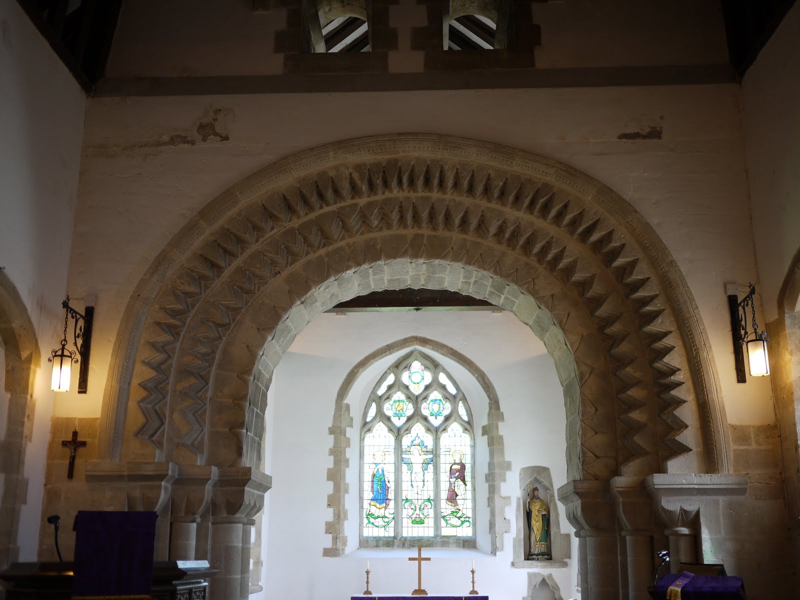
Once in Worth we went to see the Norman church of St Nicholas of Myra. The church dates from the 11th century.


Inside, the magnificent chancel arch, of about the same date (says Pevsner) was apparently brought to the church from elsewhere, probably after the dissolution of the monasteries.


Conditions: sunny, hot.

Distance: about 5 miles, of which only about 1.5 was on the Coast Path. Distance covered now 13.5 miles.

Map: Explorer OL15 (Purbeck and South Dorset).

Rating: four stars.


Sightings

A surprisingly good showing of butterflies: peacock, small tortoiseshell, small white, orange tip, holly blue. We only needed  red admiral, comma, brimstone and speckled wood to have a full set of the butterflies you could reasonably expect to see in early April.


Flower of the day

I haven't been able to identify these delicate blue flowers we saw on the grassy hillside above the coastal path.