Wednesday 26 June 2013

36 Hope Cove to River Erme

Hope Cove

We set out from Hope Cove with quite a long section in prospect: 9.2 miles to the River Erme, one estuary where there is no ferry, although you can apparently walk across at low water. In between lies the inconvenient River Avon, where the ferry only runs 1000-1100 and 1500-1600.

We immediately made things worse by failing to spot a diversion sign affecting the path at nearby Thurlestone Sands, which meant we had to back-track before actually making the 1.5 mile detour inland to avoid a cliff-fall.

As we climbed up the hill away from the beach there was a good view back over the bay, with the arched Thurlestone Rock very prominent.


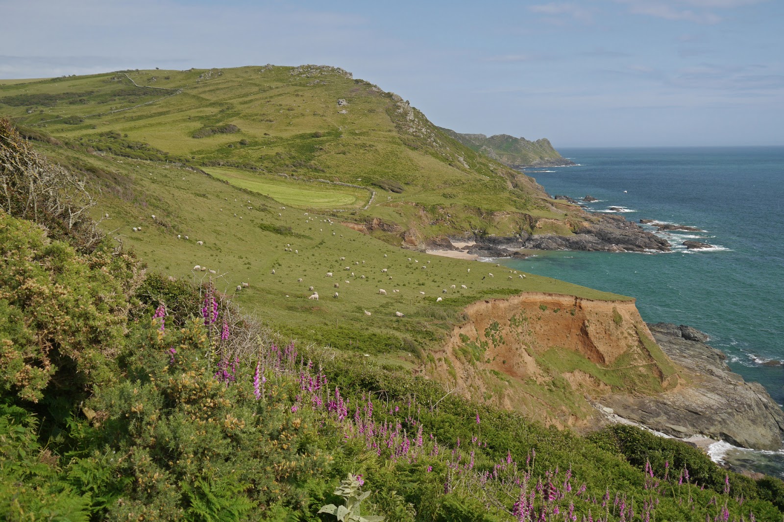
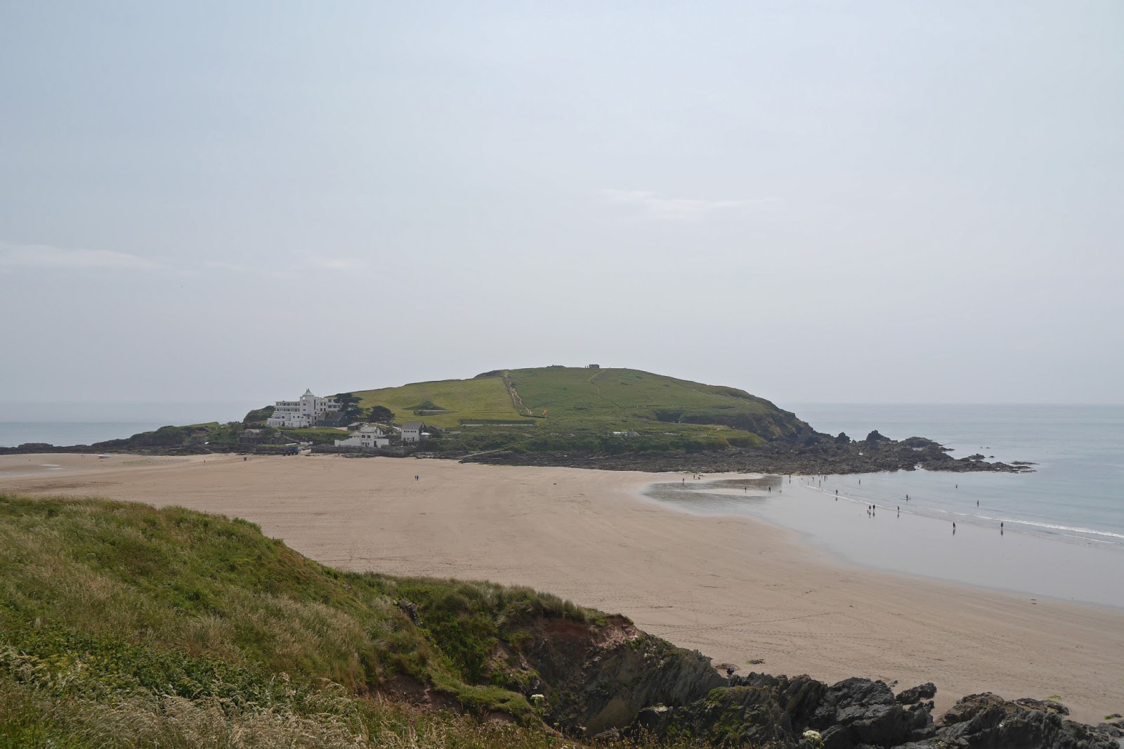
We now followed a low grassy headland path overlooked by Thurlestone Golf Course. This climbed quite steeply and then descended to reach the mouth of the Avon, with a lovely view across to Burgh Island. This is a tidal island connected to the mainland at Bigbury-on-Sea by a sandy strip. You can only walk over at low water. It is known for its links with Agatha Christie, who holidayed at the art deco hotel and set two novels there.


Carrying on down to almost sea level, there was a nice view along the Avon estuary. 


We had solved the problem of the inconvenient ferry times by arranging for a taxi to meet us at the Sloop Hotel in Banham just along the river. Fast, if rather stressful, walking (we knew the driver had another fare booked soon after us), enabled us to reach Banham in time and we were whisked away to the other side of the river. From here we walked down to Bigbury-on-Sea, where we spotted another small, pretty and as yet unidentified, flower.


After a break for lunch at the Venus cafe, we headed uphill and away from Bigbury. There was another nice view of the island.


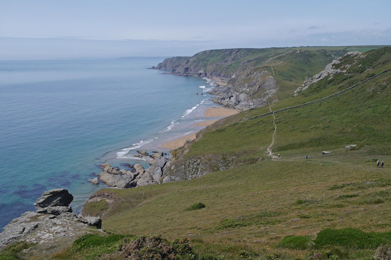
We passed through Challaborough, a rather poor cousin to Bigbury, with holiday homes and grey sand. Then we began a long climb to Toby's Point, which offered a welcome bench to sit on and fantastic views over the next, dramatic section of coast. We chatted to a chap who was already there, having walked up from Challaborough, and who seemed set to spend the afternoon there. He said he would watch us as we struggled on.


We began the descent to Aymer Cove, passing a rocky crest and noticing a strange black tower on the left at sea level.


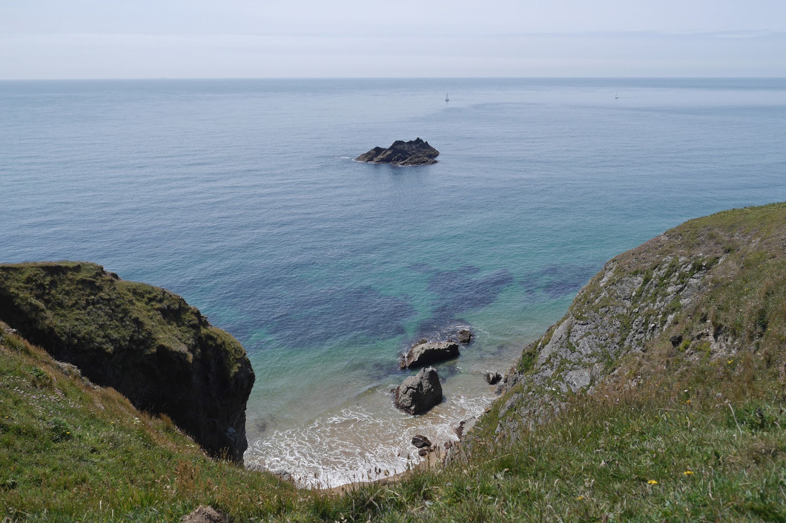
The Cove itself had even more startling rock formations.


Now there was a steady climb, followed soon after by another steep descent, to Westcombe Beach and then an extremely steep climb to reach Holst Point. We actually went straight up the hill, only discovering at the top that there was a zig-zag path in the long grass which might have been easier.

The final section along the coast was easier - just as well! - and at one point there was a wonderful sense of the whole of Bigbury Bay. Bolt Head can be seen in the distance behind Burgh Island.


Along this section I saw two Painted Ladies, the first of the year. Now we turned Beacon Point and entered the unspoilt estuary of the River Erme.


We followed the estuary back to where we had left the car, at Wonwell Beach. The tide was just coming in - quite quickly it seemed. Perhaps we would have been in time to cross ...


Conditions: hazy cloud, with a threat of rain which fortunately did not materialise, but warm.

Distance: the best part of 11 miles in all, of which 9.2 count as forward progress. Distance now covered 194.3 miles.

Map: OL 20 South Devon.

Rating: Four and a half stars.

Tuesday 25 June 2013

35 Salcombe to Hope Cove

Salcombe Harbour

We started from the ferry pier in Salcombe and walked up the hill out of the town, amazed by how many shops there were selling men's casual clothing - if only there was time to investigate properly! After passing the beaches at North Sands and South Sands, a steep wooded path leads up to the National Trust property, Overbeck's, famous for its gardens and eccentric collections more than for its architectural merit. There were many fine views back towards Salcombe harbour.

You continue in woods after the house and we were very taken by these tiny flowers, about the size of a Herb Robert. As so often, I have failed to identify them.


We emerged into more open country and soon found ourselves looking down on the greeny-blue water of Starehole Bay, with Bolt Head on the far side.


My eye was caught by an emerald-green insect and when it landed on some ivy, I realised there was  a Green Hairstreak nearby. I was delighted - a new sighting for me.


This was the view back over the bay from Bolt Head, with Limeberry Head behind.


We paused at a bench which offered great views in all directions and I quickly became aware of a number of quite large, fast-flying orange butterflies. I leaped up and pursued them downhill over the bracken. It was a bit like the poor traveller being lured off his path by a will o' the wisp in a fairy story. By the time I was getting close to the cliff edge at the bottom of the slope I was no nearer to getting a photo or a clear sight of the all-important under-wing markings which enable one Fritillary to be told from another. Subsequent research strongly suggests they were Pearl-bordered Fritillaries: the continuous flight a metre or so above the ground (searching for newly emerged females) is characteristic, bracken covered scrubby hillsides are a known habitat and South Devon one of the few areas where they are found. Exciting, but frustrating that I couldn't get a picture or even a clear visual impression.


We climbed up to a rocky saddle and then descended to enter the large plateau known as The Warren. There were further intermittent Fritillary sightings as we went along.


Ahead of us for much of the way was this lovely square tower and I made a slight detour inland to take a picture. I have found a couple of other photos of it by Googling, but no information about what it is or was.


After Steeple Point ...


... there is a sharp change  and the path descends steeply revealing a dramatic coastline ahead.


After the descent, you climb again - it is the coast path after all - and a pretty, small cove offers a view of the Ham Stone out to sea.


Then, after some tantalising glimpses, the fantastic sight of Soar Mill Cove unfolds in its full glory below.


A steep descent brings you down to sea level where the pair of rocks known for some reason as the Parson and the Clerk dominate the view. Perhaps unconvincingly, this put me in mind of our first sight of Hahei beach on the Pacific coast of New Zealand's North Island.


After a steep climb up the other side, we now followed a ridge-top path, with a green valley on the landward side.


Now we crossed Bolberry Down, at the end of which there was a dramatic view between two rocks back along the coast.


Soon after this we reached the grassy promontory known as Bolt Tail, overlooking Hope Cove and with Burgh Island, which dominates the next section of coast, beyond.


Just as we were going through a gate, I spotted another Fritillary, smaller and less brightly orange than the ones we had seen earlier in the walk. This one too wouldn't reveal its under-wings, but I have subsequently identified it as a Small Pearl-Bordered Fritillary - another new sighting!


We followed the grassy trail to come down into Inner Hope, where there is an unexpected but  delightful group of thatched cottages.


We had parked in Outer Hope, so we completed our walk by crossing the beach - it was low water - and marveling at the pale pink stones which were scattered across it.


Conditions: sunny and warm.

Distance: 8 miles. Distance now covered 185.1 miles.

Map: OL 20 South Devon.

Rating: Five stars. An excellent day for butterflies (we saw another ten species, including a Wall, beyond those mentioned). The scenery around Soar Mill Cove is some of the best we have yet seen. 

Monday 24 June 2013

34 East Prawle to Salcombe


Lannacombe Bay

On our last visit (1 May) we had to make a detour off the coast path because of a cliff fall at Lannacombe. We started today at the edge of East Prawle, where we ended up last time, and walked back to rejoin the detour route and then find our way down to the coast path itself, just a few hundred yards from where we had left it. There was soon a nice view back over Lannacombe Bay. On the way down I spotted these delightful flowers on a hedgerow shrub.


We advanced along a low cliff top, surprised to see corn growing so near to the coast, and at Langerstone Point had a fine view across to Prawle Point, with its lookout station above and sea arch below.

The section leading to the point was across a low grassy area almost at sea level. Somewhere along here I saw what I have since identified as a Gannet - a gull-like bird with white wings with black bars at the ends, which dropped into the sea a few times in the manner of a Tern. It's always good to add a bird to the list I those I can identify!


But then the path climbed to reach a curious enclosed area bounded by stone slabs a little like gravestones. This wall went down both sides towards the sea and across the inland side parallel to it, creating a sort of field, albeit only with wild flowers. The overall effect was quite eerie. We have read elsewhere that stones like these are used as boundary markers.


There was a fine view head to Gammon Point and as we came closer we saw a number of Fulmars in the air and nesting on the cliffs.


We paused above the sandy Maseley Cove, which can be seen in the picture above, for a light lunch.


Soon a longer view of the coastline became available and the entrance to Salcombe Harbour could be seen, with Bolt Head on the extreme left.


We admired the quiet sandy beach at Seacombe Sands ...


... and were staggered by the profusion of Foxgloves in the hillside above. Foxglove had certainly been the signature flower of this section of coast, but we had not previously seen such a concentration.

We climbed steadily to pass below Gara Rock, where there is clearly a splendid new modern hotel. There were great views back, with yet more Foxgloves.


Looking up, you could see the old lookout point.


The final section passed below Portlemouth Down through some very nice woodland to round Limeberry Point and enter the wide estuary known here as Salcombe Harbour. Sunny Cove is on the right, with Salcombe itself on the other bank. Beyond Sunny Cove is the lovely sandy beach at Mill Bay.

By the time we reached Salcombe we had just missed the last ferry, but a helpful resident gave us the number of a water taxi and after a not unpleasant wait in the evening sun, we enjoyed a delightful short trip across the harbour.

This is the view up the Kingsbridge Estuary as the more inland body of water is known. It is a substantial area of water, with several creeks off it.


It is not in fact an estuary properly speaking, because it is not the outlet of a river. I learn from Wikipedia that it is an example of a ria, "a coastal inlet formed by the partial submergence of an unglaciated river valley - a drowned river valley that remains open to the sea". A creek, on the other hand, is a tidal inlet of the sea. Estuaries form an important aspect of the south Devon coastline, so it is good to be clear about these distinctions.

Conditions: cloudy at first, but war.

Distance: 8 miles in all, of which 6.5 were on the official coast path. Distance now covered 177.1 miles.

Map: OL 20 South Devon.

Rating: Four stars.