The end of the South West Coast Path
This is the final leg of the SW Coast Path! We set off from Porlock Weir in light drizzle, looking across the rocky beach towards Hurlstone Point. A small tower can just be made out part-way up.
We followed the road through the village and turned left to walk along the back of the beach for a while, passing the wooden stakes indicating the oyster beds.
Soon we had to turn inland because of a "breach". We followed a well-trodden path which eventually turned back towards the sea, passing a dramatic stand of dead trees.
We passed through the pretty village of Bossington, where we especially admired the brick columns of the cattle byre attached to one house.
We then began a long climb, passing inland of Hurlstone Point and thereby missing the small tower which we had seen from afar. I learn from Google that it is a coastguard lookout tower which was built in 1902, and remained in use until 1983.
We were now climbing Hurlstone Combe where we soon reached the heather line and plodded on up the long slope.
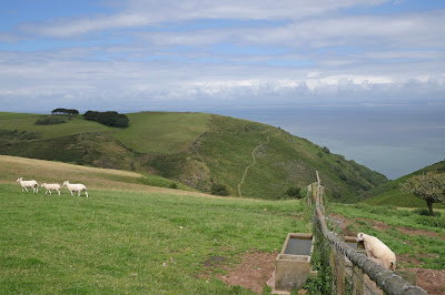
At the very top there was a great view back towards Porlock Weir ...
... and also a fine one inland towards Porlock.
Soon afterwards we ignored the sign for the "Rugged Coast Path" to continue along the regular Coast Path across moorland, passing Selworthy Beacon at 308 metres, only 10 metres lower than the Great Hangman which we climbed recently on the Combe Martin to Hunters Inn section. It turned out that we had somehow drifted off the official path at this point and it took us a while to edge our way back onto the correct route.
By the time we achieved this we were opposite Grexy Combe with North Cliff largely out of shot to its right. The trees were quite picturesque.
As we approached Minehead we were rejoined by the Rugged Coast Path. We were still over 200m above sea level and soon the path made a zig-zag turn towards the sea. The variations in colour were fascinating.
We descended steadily and entered some woodland, emerging eventually onto a minor road which took us into Minehead. It was interesting to see the stony beach in the foreground and the sandy one in the distance. We concluded that at some point in time the rocks had been cleared from the sandy area.
We headed inland in search of the Duke of Wellington in Wellington Square. We passed these rather lovely Coastguard Cottages built in a lovely red sandstone, which we quickly discovered was characteristic of the town.
Just before Wellington Square is Mansion House Lane where the Quirke Almshouses are to be seen. Founded 1630 by Edward Quirke, merchant and mariner, and restored 1986. Note the bellcote at the far end: it reputedly houses a bell from one of Robert Quirke's ships.
Wellington Square is home to St Andrew's church, in front of which is this fine statue of Queen Anne, by Bird who made the similar one which stands outside St Paul's in London.
We now adjourned to the rooftop beer garden of the Duke of Wellington to celebrate our completion of the South West Coast Path with a nice bottle of Wetherspoon's reasonably priced Moet et Chandon.
Conditions: Quite warm, but mainly cloudy.
Distance: 9.5 miles.
Map: Explorer OL 9 (Exmoor).
Grading: Moderate.
Rating: four stars.


