Sunday 27 April 2014

50 Portscatho to St Anthony

 Portscatho beach

This is the final walk of this trip and we set off from Portscatho following the sea front. This is a bit of a novelty as the last two walks have begun with a steep climb. It is low water and the beach looks more interesting that we had realised.

There is soon a great view across a very calm Gerrand Bay and yesterday's landmarks, Nare Head and Gull Rock are very clear, with the day before's, Dodman Point, also in view behind.


We are soon walking along a grassy low cliff and noticing how different this section of coast is: low rocky shelves rather than sandy coves.


This soon gives way to the large sandy expanse of Towan Beach.


At the back of the beach is a what looks at first sight like a sort of totem pole, or perhaps something for kids to climb up. It turns out it is called the Wreck Post was put there by the coastguard to help practice rescuing people from a ship using a breeches buoy. It is meant to simulate a ship's mast.


A little further on you come to Kilgerran Head where there another fine view back.


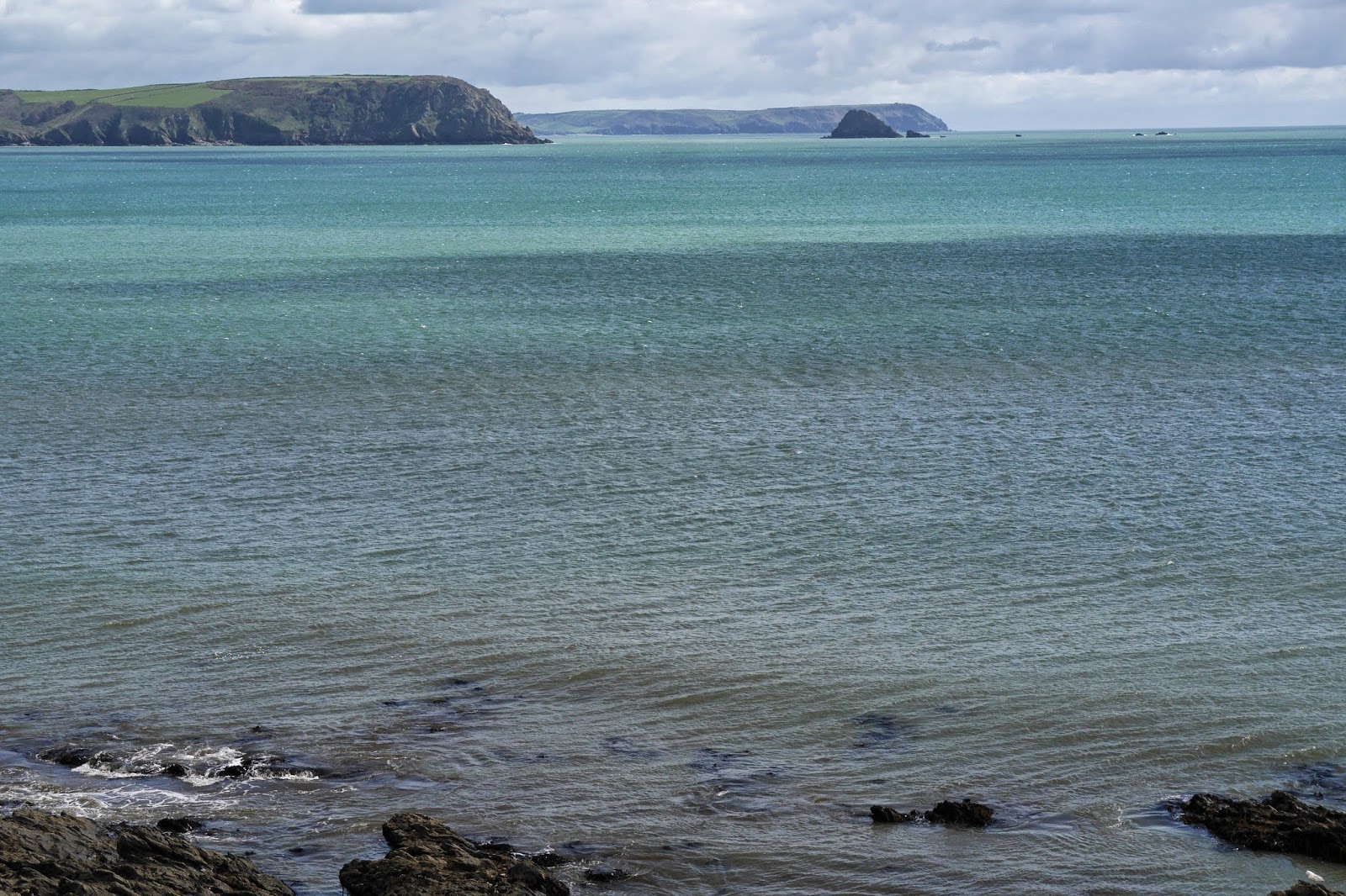
The view west is lovely too, with The Lizard on the horizon and Zone Point in the foreground. 


As we head uphill towards zone point we pass above the inviting sandy beach at Porthbeor. Unfortunately, according to a National Trust notice, there is now no safe way down following a rock fall. Suddenly the view to the right opens up with a view across to St Mawes on the other side of the Roseland Peninsula.


 Soon after this, we reach St Anthony Head and pass the remains of World War II gun emplacements.
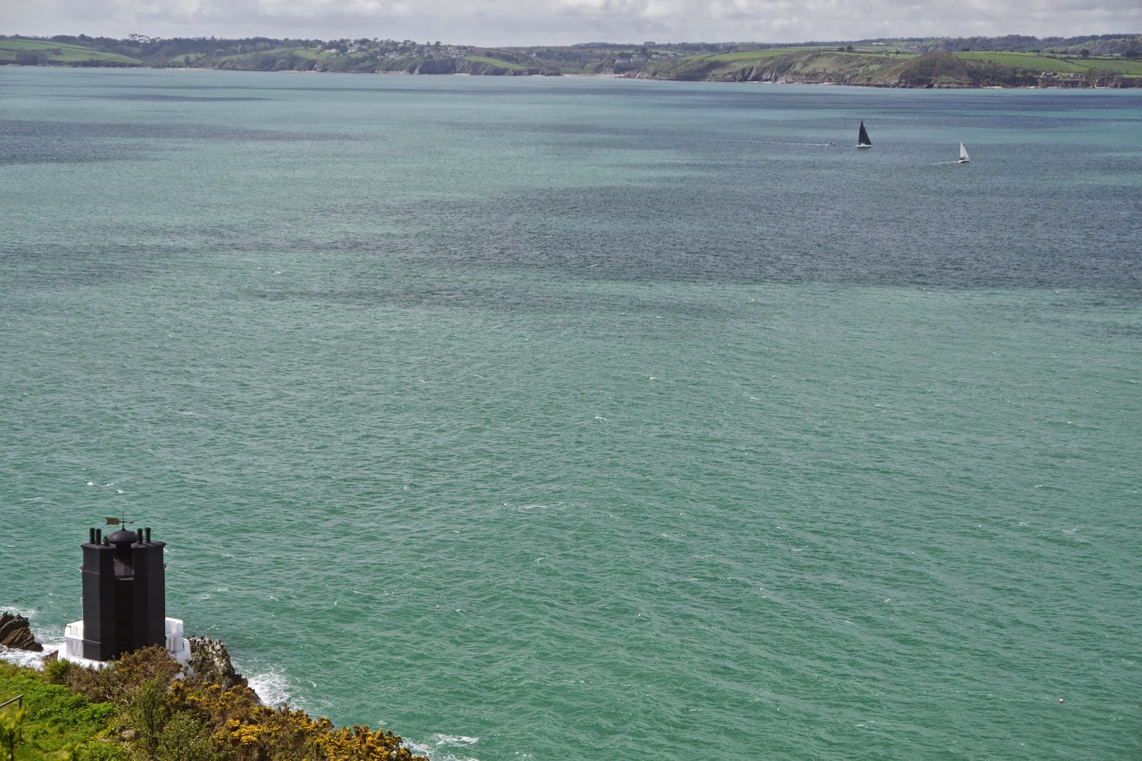
 Pendennis Castle can be seen across Carrick Roads, with Falmouth behind.


This is another view across Carrick Roads, with the top of the St Anthony lighthouse.


We climb down to near the waterside to continue round towards Place House and soon enjoy this fantastic view towards St Mawes castle. It was built 1540-43 and was one of the large network of coastal defences constructed by Henry VIII.


Around about here the path was definitively closed by a rockfall and we had no option but to turn back.

Conditions: warm and bright.

Distance: 6.2 miles. Distance now covered: 295.4 miles.

Map: Explorer 105 (Falmouth & Mevagissey).

Grading: Easy.

Rating: four stars.

Saturday 26 April 2014

49 Portloe to Portscatho

 Looking back to Portloe

After such a lovely day yesterday, we knew from the weather forecast that today would not be so good and we duly set out from Portloe in cloud and drizzle. We made the inevitable steep climb up out of the village and headed along the cliff to turn Menare Point, and lose sight of Portloe behind us. We could see the headland of The Blouth ahead with Gull Rock beyond it.


Having crossed it, we descended a steep-sided grassy bottom at the back of Kiberick Cove. This is the view looking down from the opposite side.


As we approached the main landmark of this leg, Nare Head, it began to rain heavily and photography had to be suspended as we plodded on in driving rain. Just as we turned the corner, the rain abated and we saw the expanse of Gerrans Bay, with what looked like rather lower cliff tops ahead than we have become used to.


We gradually descended to sea level from the 90 or so metres of Nare Head and had a good view along wave-tossed Carne Beach. Portscatho is the white smudge on the left.


We decided to break for lunch at the Nare Hotel. This was the view back over the beach towards Nare Head. It is just possible to make out two dots in the water which are all that is visible of two mad boys using their body boards.


We had a pleasant enough lunch in the hotel dining room, feeling slightly out of place in our wet walking clothes, and looped round the hotel to rejoin the coast path. Unfortunately, it had started raining again. After Pendower Beach, we followed the high path along a sloping cliff where there was a most impressive crop of Early Purple Orchids.

We descended to briefly walk on Portbean Beach and climbed up through what seemed to be an abandoned garden to descend again to a (Coastguard?) lookout station. There was a nice view back to Nare Head and Gull Rock in a spell of late afternoon sunshine.


Across the small bay, Portscatho, still surprisingly far away, glistened whitely.


Conditions: wet at first, but brighter later.

Distance: 7.5 miles. Distance now covered: 289.2 miles.

Map: Explorer 105 (Falmouth & Mevagissey).

Grading of this section: Moderate.

Rating: 3 and half stars.

Friday 25 April 2014

48 Gorran Haven to Portloe


Back on the South West Coast Path. We climbed up from Gorran Haven and enjoyed a great view over the deceptively large beach.  As we walked along the grassy cliff top there was soon (minor) excitement when I spotted my first Green Veined White of the year.

We followed a charming path descending towards sea level.


We followed the path round the headland and had our first views of Dodman Point, with Bow or Vault Beach (it says on the map)  in the foreground. 


Once we reached Dodman Point we saw that there is a large, but rather crude, cross erected in 1886. The Lizard can be glimpsed on the horizon to the left.


The next section of coast stretched away invitingly.


We followed a grassy cliff top path to reach to a rather nice, quiet beach at Hemmick.


Greeb Point offered a nice view back over this part of Veryan Bay towards Dodman Point.


After a while, we reached Portluney Cove, with Caerhays Castle improbably behind it.


Seen from the road which passes the back of the beach, the castle is undeniably picturesque. It was built in 1808 by John Nash of Brighton Pavilion fame for John Bettesworth-Trevanion. Later in the 19th century new owners opened up the view to the sea. It now has a garden famous for its collection of magnolias and azalias.


The next landmark was the very exposed village of East Portholland with its substantial sea defences.


A little further along is the smaller West Portholland where we visited friends in October 2006 and had our first and never-to-be-forgotten encounter with the coast path. We were dropped off somewhere - we can't quite remember where - and walked back to their house. It took us far longer than we could ever imagined and we arrived in the gathering dusk with them wondering what had happened to us. A couple of photos from 2006 strongly suggest that we walked from Portscatho, via Portloe - 9.5 miles. Well outside what we what we would have regarded as normal!


Just beyond West Portholland there was a fine view across the whole bay to Dodman Point. We never tire of saying "look how far we've come".


The final two miles to Portloe are rated as strenuous and this was well justified. I did see however see my first Wall (or Wall Brown) butterflies of the year.  Soon afterwards we encountered a rather ill-matched couple: she was wearing black leather boots and a dress, he was wearing walking clothes. We wondered if perhaps they had met for a first date with rather different expectations.

The wildflowers, which we had seen in profusion all day, were extremely numerous. It was like walking through an overgrown herbaceous border.


We were also struck by dense drifts of bluebells on both sides on the path on one sloping section. 


As we approached Portloe, we could see the next big landmarks - Nare Head and Gull Rock, with Zone Point behind them. One of the inlets concealed Portloe, but which one would it be?


Of course, it was one of the further ones, but finally we made it to the pretty village of Portloe.


Conditions: mostly bright and sunny, but clouding over towards the end.

Distance: 8.8 miles. Distance now covered: 281.7 miles.

Map: Explorer 105 (Falmouth & Mevagissey).

Grading: Moderate becoming Strenuous.

Rating: four stars.