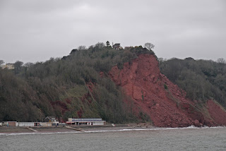
Cliff fall at Oddicombe Beach
Day 2 of our latest Coast Path trip. Yesterday we walked from
Shaldon to Babbacombe. I had found a walk around Babbacombe on the Royal Geographical Society's
Discovering Britain
website and so we started by investigating a house called Babbacombe
Cliff. It was not particularly inspiring as a building, but its main
claim to fame was that Oscar Wilde wrote
A woman of no importance there.
We
retraced our steps across the grassy Down in front of the hotel and
then went down past the funicular to Oddicombe beach, the site of a
major rock fall in 2010. We followed the coast path as it skirted the
bay and at sea level got the clearest view of the cliff fall and what it
meant: if you look closely at the photo you can that one of the houses
on the top of the cliff tragically seems to be missing its whole right
side.
Now began the inevitable long climb up from sea
level to begin to walk around the series of headlands that separate
Babbacombe from Torquay. Pevsner comments on the "exceptionally
fortunate geographical situation" of Torquay, which has allowed it to
keep "its various parts in attractive isolation from each other".
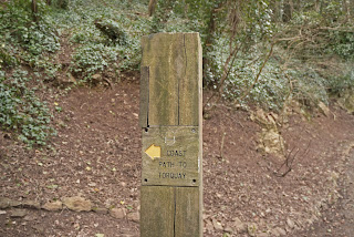
I thought I had better capture the sturdy new style signs which are in use in this part of the coast path.
We
walked across the flat grassy area known as Walls Hill. The Discovering
Britain walk guide explains that these flat cliff-top areas are known
as "plains"and were formed tens of thousands of years ago when the sea
was much higher than it is now: "wave-cut platforms" is the technical
name.
We next passed Redgate Beach, closed to the
public since 1998 because of falling rock. Apparently there was a local
outcry at the time, but no doubt there would have been an even bigger
one if someone was killed by a rock slide.
Soon we
came to Anstey's Cove, with Devil's Point at its left side. We had
noticed these points of rock on our walk yesterday and it seems they are
nothing more than bits of a former quarry that proved too difficult to
cut. Why not rename them the Dragon's Teeth?
At Black Head there was good view towards Hope's Nose with Ore Stone beyond it.
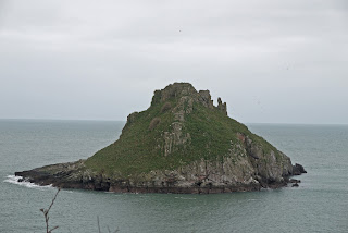
Now we finally turned the corner of Babbacombe Bay and found ourselves facing the fine sight of Thatcher Rock.
A
bit further on, behind Meadfoot beach, we passed an intrusive modern
block flats and then came on the Osborne hotel, offering "elegance at
modest prices". It is a large Georgian style building with an elegant
frieze and fine pediments at either end. It was built as Meadfoot
Crescent in 1848 and renamed Hesketh Crescent in 1949. It was very
striking how much better it fitted into the environment than the vast
modern structure at the other end of this bay.
Now
we climbed to a grassy area (the strangely named Daddyhole Plain) by
the Coastguard station where there was this lovely group of presumably
early Victorian houses painted in delightful pastel shades - all except
the one in the middle.What must the others be saying?
Turning
another corner, we began the final approach to the centre of Torquay.
The path passed through a delightful folly tower ...
... and descended to pass the Living Coasts coastal zoo. It was a surprise to see penguins on this walk!
Then down to the harbour, past a row of house with lovely iron balconies.
The view across the harbour was very pleasing, with GE Street's St John's church in the background.
Advance study of Pevsner had alerted me to the fact that the church
features stained glass by Morris and Co, designed of course by
Burne-Jones, who also painted two walls in the chancel. To our intense frustration, it was locked.
Also
on the landward side of the harbour was this delightful clock tower. I
imagined it must be another Jubilee Clock for Queen Victoria, but it
turns out that it was a memorial for Richard Mallock who owned nearby
Cockington. It was designed by John Donkin and erected in 1902.
After
a break for lunch in Hoopers department store, we headed across to the
Pavilion, which dates from 1912 in a mixture of classical and
art nouveau styles. It is currently closed, pending re-development.
We walked along the sea front and were struck by the wide expanse of sand.
Set
back from the beach is Torre Abbey, dating originally from 1198. After
the dissolution of the monasteries the former gatehouse was remodeled
into a house and later a Georgian extension was added. This is all
closed for restoration at present. To the right is the Tithe Barn, which
Pevsner thinks could date to the 13th century. It is a handsome
structure.
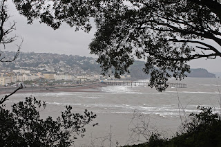
The last leg of the walk was a plod along the main road, finally relieved by the first glimpse of Paignton.
We followed the road down to the sea front which we followed down past the pier to the small harbour, where we called a halt.
Conditions: cold, grey.
Distance: officially 7 miles, but it seemed rather longer. Distance now covered 137.6 miles.
Map: Explorer 110 (Torquay and Dawlish).
Rating: Four stars.
Sightings
Quite
a lot of colour: white bluebells, violets, red campion and this lovely
yellow shrub growing in profusion on the slopes as we made our approach
towards Torquay.


