Saturday, 19 February 2011

4 Anvil Point to Dancing Ledge

The lighthouse at Anvil Point

On a brief visit to Poole we saw a chance to make a little further progress along the Coast Path. We parked at Durlston Country Park and followed a winding tarmac path down towards Anvil Point to resume our route. According to the Trinity House website, the lighthouse dates from 1881 and was opened by Joseph Chamberlain, father of Prime Minister Neville Chamberlain.

There was a fine view down to the lighthouse as we drew closer. Out to sea the sun broke through the clouds in a few places creating bright circles on the surface: a searchlight from heaven.

Before reaching the lighthouse there is a small preserved stone quarry, with a little four wheeled cart, called a quarr, used to bring the stone up.


We joined the Coast Path, initially walking along a grassy area, but soon joining a narrower and increasingly muddy path. We rapidly formulated a law to the effect that the depth of the mud was inversely proportional to the width of the path - some of the narrow sections were extremely sticky.

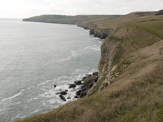
This section of the Coast Path is fairly straight, without major features. We went through a National Trust section named Belle Vue, although it did not seem any more belle than the adjoining areas. The first landmark was Blackers Hole and there were by now impressive views along the coast towards St Aldhelm's or St Alban's Head.


Another half a mile or so of struggle through the mud and we came to Dancing Ledge.


We found our way down the ledge itself and noticed that some climbers had descended from there down to sea level to make an assault on the cliff face further along. We naturally had a little dance on the ledge, doing some of our favourite jive moves.

We had planned this walk by reference to the map and now climbed the steep hillside leading to the ridge which runs parallel to the coast along this section - an ascent of about 50m. On the way up we saw our first daisy of the year, which we found strangely cheering. At the top we briefly sat and enjoyed the feeling of the warm sun on our faces - for a moment we felt that we might have been in Nice.

The walk back along the ridge was a delight by comparison with the walk out and we fairly sped along over the short grass. The sky had cleared somewhat and we were surprised by how blue the sea was in places.


The route continued over grassy paths interspersed with dry stone walls.


We reached Round Down and soon returned to the car.

Conditions: cloudy, some sunshine, about 9 degrees; did I mention that it was very muddy underfoot?

Distance: about 5 miles, of which about 2.5 was on the Coast Path. Distance covered now 12 miles.

Map: Explorer OL15 (Purbeck and South Dorset).

Rating: four stars.

Sunday, 6 February 2011

3 Swanage to Anvil Point


Swanage Beach

We used the visit of our friends Judith and Tony to continue our progress along the South West Coast Path. We skipped a couple of suburban streets in New Swanage and picked up the route at the start of the Swanage sea front.

At the end of the sandy beach we passed the curious column with three cannon balls on the top erected by John Mowlem (the founder of the building company) in 1862 to commemorate the defeat of a Danish fleet in 877 in Swanage Bay by King Alfred. This does invite some questions - mainly, why?

We followed the edge of the bay and then detoured to pay our 40p and walk along the Victorian pier. According to Swanage Pier Trust website, "The original Swanage Pier was constructed in 1859/60 by James Walton of London for the Swanage Pier and Tramway Company and opened by John Mowlem. The Pier was built primarily for shipping stone. Horses were used to pull carts along the narrow gauge tramway which ran along the Pier and seafront." We had noticed traces of the railway as we walked around towards the pier. The original pier was found to be too small and was rebuilt in the 1890s.

There is a fine view from the pier towards the Wellington clock tower. There is a wonderful story behind this. It was originally built in 1854 in honour of the Duke of Wellington near London Bridge, but was soon found to be impeding the traffic and taken down. George Burt, a nephew and business partner of John Mowlem, of whom more will be heard shortly, removed the stones to Swanage and rebuilt the tower in its present location. The clock never followed, and a spire was removed in 1904 as it had become unsafe.


We left the pier and continued on our way to pass a pair of Ionic columns, which mark entrance to Prince Albert Gardens. They were apparently date from the early 19th century and were brought to Swanage by John Mowlem, who clearly liked his columns.


A little further on there was a fine view looking back to the pier. Its dog-legged character was more evident from this vantage point.


 We now climbed up to skirt Peveril Point with its lighthouse and continued to climb as we walked along a grassy cliff overlooking the sea. After a short detour along a road we entered Durlston Country Park and walked along a well made path to pass beneath Durlston Castle. The Castle's website explains that it was built as a restaurant by George Burt and was part of his grand plan to create an exclusive housing estate on his land as part of his dream of transforming Swanage into a fashionable resort. The castle is currently under restoration and most of it is hidden under scaffolding.


A little further on, right below the Castle, is the Great Globe, 40 tons of Purbeck stone with a map of the world, nestling in an enclosure in which there are a series of stone plaques carved with quotations from poets and the Bible, as well as facts about the natural world.


We now followed the path above Tilly Whim Caves. (A whim was apparently a type of crane or hoist and Tilly was possibly a quarryman. As just-so stories go, we thought this was pretty weak.) Soon we reached the lighthouse at Anvil Point.


Here we left the Coast Path, turning inland to climb Round Down. From here a grassy track which later joined a road led us down to Swanage High Street, where we saw another wonderful contribution to Swanage's character from the indefatigable George Burt. This is the Town Hall.


It is essentially an unremarkable building to which has been added a superb facade by Sir Christopher Wren no less. Burt rescued it from the Mercers Hall in London's Cheapside.

We now retraced our steps to the start and  enjoyed an excellent lunch at the Ocean Bay restaurant.

Conditions: cloud, drizzle and rain, about 9 degrees.

Distance: about 5.5 miles, of which about 3 was on the Coast Path. Distance covered now 9.5 miles.

From: 50 walks in Dorset (AA) - but from a different starting point and with the sea front element as an addition.

Map: Explorer OL15 (Purbeck and South Dorset).

Rating: four stars.